You are here: Home > Network List > TA - USArray Transportable Network (new EarthScope stations) Stations List
> Station I12A Atlanta, ID, USA > Earthquake Result Viewer
I12A Atlanta, ID, USA - Earthquake Result Viewer
| Earthquake location: |
Chile-Argentina Border Region |
| Earthquake latitude/longitude: |
-24.8/-68.5 |
| Earthquake time(UTC): |
2007/11/21 (325) 12:55:05 GMT |
| Earthquake Depth: |
115 km |
| Earthquake Magnitude: |
5.6 MB, 5.8 MW, 5.8 MW |
| Earthquake Catalog/Contributor: |
WHDF/NEIC |
|
| Network: |
TA USArray Transportable Network (new EarthScope stations) |
| Station: |
I12A Atlanta, ID, USA |
| Lat/Lon: |
43.79 N/115.13 W |
| Elevation: |
1849 m |
|
| Distance: |
80.6 deg |
| Az: |
327.731 deg |
| Baz: |
137.932 deg |
| Ray Param: |
0.0479298 |
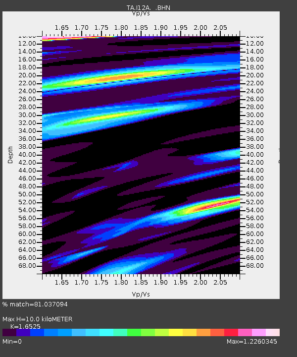
| Estimated Moho Depth: |
10.0 km |
| Estimated Crust Vp/Vs: |
1.65 |
| Assumed Crust Vp: |
6.291 km/s |
| Estimated Crust Vs: |
3.807 km/s |
| Estimated Crust Poisson's Ratio: |
0.21 |
|
| Radial Match: |
81.037094 % |
| Radial Bump: |
338 |
| Transverse Match: |
63.746147 % |
| Transverse Bump: |
384 |
| SOD ConfigId: |
2564 |
| Insert Time: |
2010-03-06 03:28:05.929 +0000 |
| GWidth: |
2.5 |
| Max Bumps: |
400 |
| Tol: |
0.001 |
|

Signal To Noise
| Channel | StoN | STA | LTA |
| TA:I12A: :BHN:20071121T13:06:34.175012Z | 2.0157793 | 3.624536E-7 | 1.7980818E-7 |
| TA:I12A: :BHE:20071121T13:06:34.175012Z | 1.045539 | 2.23438E-7 | 2.1370604E-7 |
| TA:I12A: :BHZ:20071121T13:06:34.175012Z | 4.3488135 | 7.708668E-7 | 1.772591E-7 |
| Arrivals |
| Ps | 1.1 SECOND |
| PpPs | 4.1 SECOND |
| PsPs/PpSs | 5.2 SECOND |


