You are here: Home > Network List > TA - USArray Transportable Network (new EarthScope stations) Stations List
> Station M14K Bethel, AK, USA > Earthquake Result Viewer
M14K Bethel, AK, USA - Earthquake Result Viewer
| Earthquake location: |
Near Coast Of Chiapas, Mexico |
| Earthquake latitude/longitude: |
15.1/-93.7 |
| Earthquake time(UTC): |
2017/09/08 (251) 04:49:21 GMT |
| Earthquake Depth: |
70 km |
| Earthquake Magnitude: |
8.1 Mww |
| Earthquake Catalog/Contributor: |
NEIC PDE/us |
|
| Network: |
TA USArray Transportable Network (new EarthScope stations) |
| Station: |
M14K Bethel, AK, USA |
| Lat/Lon: |
60.75 N/161.96 W |
| Elevation: |
19 m |
|
| Distance: |
66.4 deg |
| Az: |
330.14 deg |
| Baz: |
101.652 deg |
| Ray Param: |
0.057496347 |
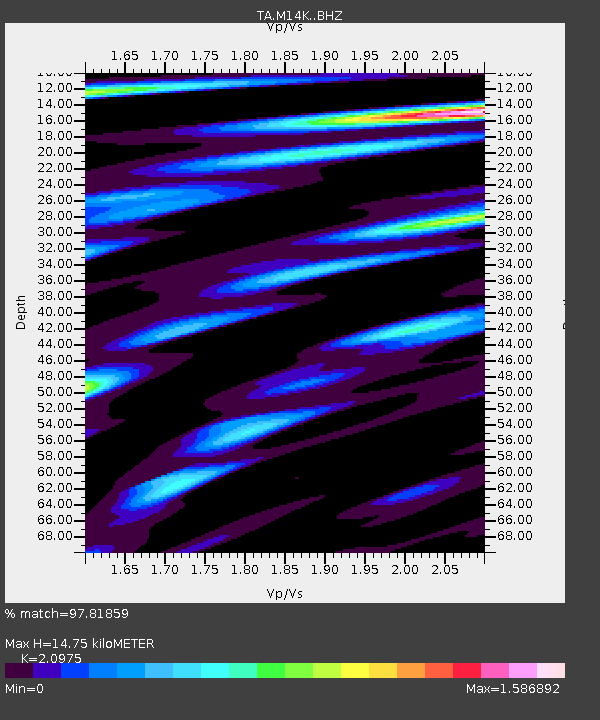
| Estimated Moho Depth: |
14.75 km |
| Estimated Crust Vp/Vs: |
2.10 |
| Assumed Crust Vp: |
6.182 km/s |
| Estimated Crust Vs: |
2.947 km/s |
| Estimated Crust Poisson's Ratio: |
0.35 |
|
| Radial Match: |
97.81859 % |
| Radial Bump: |
400 |
| Transverse Match: |
97.13237 % |
| Transverse Bump: |
400 |
| SOD ConfigId: |
13570011 |
| Insert Time: |
2019-04-28 17:28:43.579 +0000 |
| GWidth: |
2.5 |
| Max Bumps: |
400 |
| Tol: |
0.001 |
|

Signal To Noise
| Channel | StoN | STA | LTA |
| TA:M14K: :BHZ:20170908T04:59:31.699978Z | 23.03903 | 6.2948275E-6 | 2.732245E-7 |
| TA:M14K: :BHN:20170908T04:59:31.699978Z | 1.4291918 | 4.193021E-7 | 2.9338406E-7 |
| TA:M14K: :BHE:20170908T04:59:31.699978Z | 4.795906 | 1.8789616E-6 | 3.917845E-7 |
| Arrivals |
| Ps | 2.7 SECOND |
| PpPs | 7.2 SECOND |
| PsPs/PpSs | 9.9 SECOND |


