You are here: Home > Network List > TA - USArray Transportable Network (new EarthScope stations) Stations List
> Station I12A Atlanta, ID, USA > Earthquake Result Viewer
I12A Atlanta, ID, USA - Earthquake Result Viewer
| Earthquake location: |
Northern Chile |
| Earthquake latitude/longitude: |
-22.2/-69.9 |
| Earthquake time(UTC): |
2007/11/14 (318) 15:40:50 GMT |
| Earthquake Depth: |
40 km |
| Earthquake Magnitude: |
6.7 MB, 7.4 MS, 7.7 MW, 7.4 ME |
| Earthquake Catalog/Contributor: |
WHDF/NEIC |
|
| Network: |
TA USArray Transportable Network (new EarthScope stations) |
| Station: |
I12A Atlanta, ID, USA |
| Lat/Lon: |
43.79 N/115.13 W |
| Elevation: |
1849 m |
|
| Distance: |
77.7 deg |
| Az: |
328.247 deg |
| Baz: |
137.679 deg |
| Ray Param: |
0.05006951 |
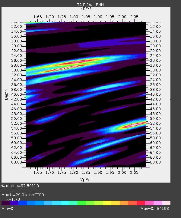
| Estimated Moho Depth: |
29.0 km |
| Estimated Crust Vp/Vs: |
1.76 |
| Assumed Crust Vp: |
6.291 km/s |
| Estimated Crust Vs: |
3.575 km/s |
| Estimated Crust Poisson's Ratio: |
0.26 |
|
| Radial Match: |
97.59113 % |
| Radial Bump: |
400 |
| Transverse Match: |
91.005264 % |
| Transverse Bump: |
400 |
| SOD ConfigId: |
2564 |
| Insert Time: |
2010-03-06 03:28:07.775 +0000 |
| GWidth: |
2.5 |
| Max Bumps: |
400 |
| Tol: |
0.001 |
|
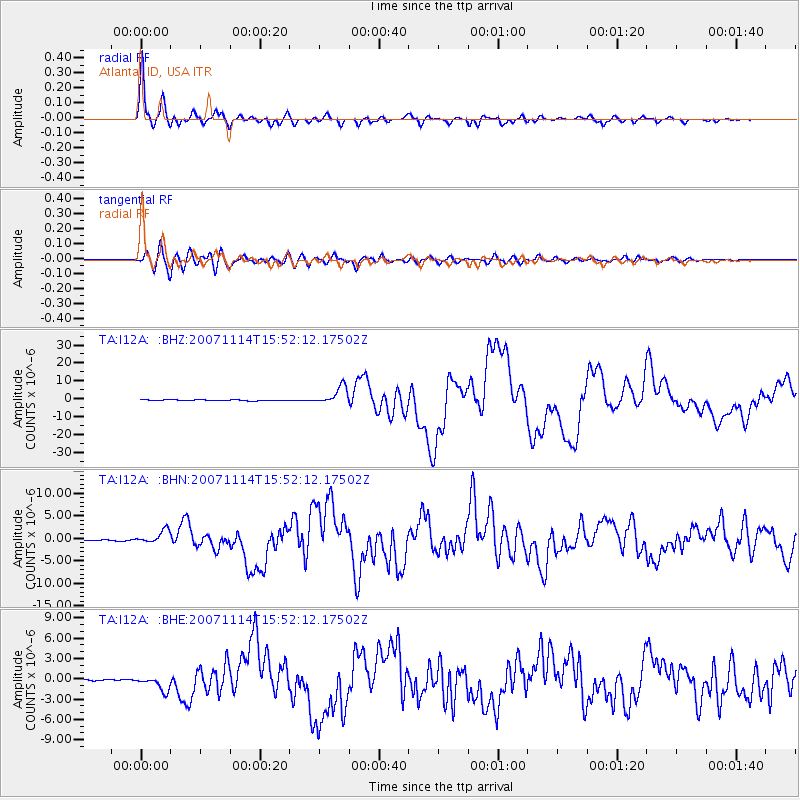
Signal To Noise
| Channel | StoN | STA | LTA |
| TA:I12A: :BHN:20071114T15:52:12.17502Z | 7.4597726 | 1.4580557E-6 | 1.9545578E-7 |
| TA:I12A: :BHE:20071114T15:52:12.17502Z | 10.523501 | 1.0646013E-6 | 1.01164176E-7 |
| TA:I12A: :BHZ:20071114T15:52:12.17502Z | 19.102282 | 4.954385E-6 | 2.5936092E-7 |
| Arrivals |
| Ps | 3.6 SECOND |
| PpPs | 12 SECOND |
| PsPs/PpSs | 16 SECOND |


