You are here: Home > Network List > TA - USArray Transportable Network (new EarthScope stations) Stations List
> Station M24K Tolsona, Glennallen, AK, USA > Earthquake Result Viewer
M24K Tolsona, Glennallen, AK, USA - Earthquake Result Viewer
| Earthquake location: |
Near Coast Of Chiapas, Mexico |
| Earthquake latitude/longitude: |
15.1/-93.7 |
| Earthquake time(UTC): |
2017/09/08 (251) 04:49:21 GMT |
| Earthquake Depth: |
70 km |
| Earthquake Magnitude: |
8.1 Mww |
| Earthquake Catalog/Contributor: |
NEIC PDE/us |
|
| Network: |
TA USArray Transportable Network (new EarthScope stations) |
| Station: |
M24K Tolsona, Glennallen, AK, USA |
| Lat/Lon: |
62.11 N/146.18 W |
| Elevation: |
908 m |
|
| Distance: |
59.7 deg |
| Az: |
334.406 deg |
| Baz: |
117.454 deg |
| Ray Param: |
0.061847676 |
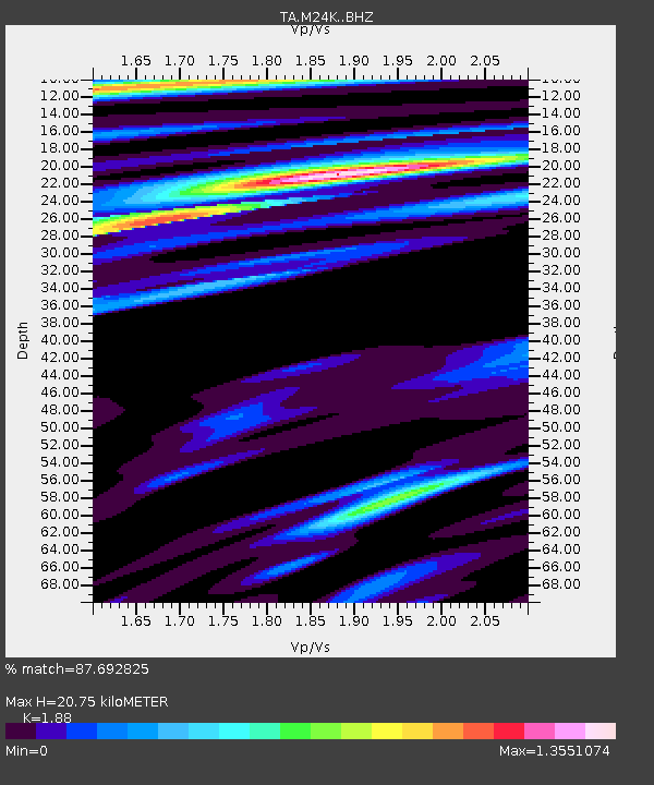
| Estimated Moho Depth: |
20.75 km |
| Estimated Crust Vp/Vs: |
1.88 |
| Assumed Crust Vp: |
6.566 km/s |
| Estimated Crust Vs: |
3.493 km/s |
| Estimated Crust Poisson's Ratio: |
0.30 |
|
| Radial Match: |
87.692825 % |
| Radial Bump: |
400 |
| Transverse Match: |
75.6432 % |
| Transverse Bump: |
400 |
| SOD ConfigId: |
13570011 |
| Insert Time: |
2019-04-28 17:28:49.261 +0000 |
| GWidth: |
2.5 |
| Max Bumps: |
400 |
| Tol: |
0.001 |
|

Signal To Noise
| Channel | StoN | STA | LTA |
| TA:M24K: :BHZ:20170908T04:58:47.52499Z | 5.376584 | 1.8213527E-6 | 3.3875648E-7 |
| TA:M24K: :BHN:20170908T04:58:47.52499Z | 1.1131618 | 3.3461265E-7 | 3.0059658E-7 |
| TA:M24K: :BHE:20170908T04:58:47.52499Z | 2.146708 | 6.150164E-7 | 2.8649282E-7 |
| Arrivals |
| Ps | 2.9 SECOND |
| PpPs | 8.7 SECOND |
| PsPs/PpSs | 12 SECOND |


