You are here: Home > Network List > TA - USArray Transportable Network (new EarthScope stations) Stations List
> Station MDND Maddock, ND, USA > Earthquake Result Viewer
MDND Maddock, ND, USA - Earthquake Result Viewer
| Earthquake location: |
Near Coast Of Chiapas, Mexico |
| Earthquake latitude/longitude: |
15.1/-93.7 |
| Earthquake time(UTC): |
2017/09/08 (251) 04:49:21 GMT |
| Earthquake Depth: |
70 km |
| Earthquake Magnitude: |
8.1 Mww |
| Earthquake Catalog/Contributor: |
NEIC PDE/us |
|
| Network: |
TA USArray Transportable Network (new EarthScope stations) |
| Station: |
MDND Maddock, ND, USA |
| Lat/Lon: |
47.85 N/99.60 W |
| Elevation: |
479 m |
|
| Distance: |
33.0 deg |
| Az: |
352.721 deg |
| Baz: |
169.53 deg |
| Ray Param: |
0.07821044 |
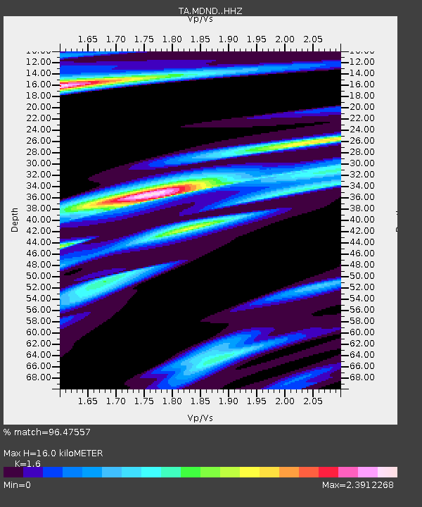
| Estimated Moho Depth: |
16.0 km |
| Estimated Crust Vp/Vs: |
1.60 |
| Assumed Crust Vp: |
6.53 km/s |
| Estimated Crust Vs: |
4.082 km/s |
| Estimated Crust Poisson's Ratio: |
0.18 |
|
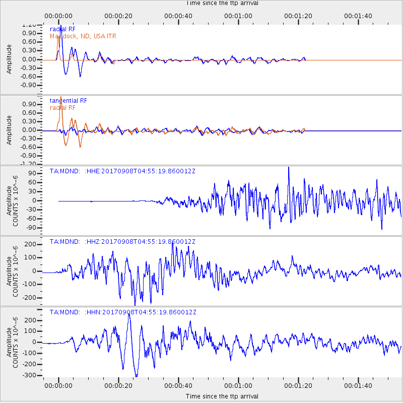
| Radial Match: |
96.47557 % |
| Radial Bump: |
279 |
| Transverse Match: |
83.741455 % |
| Transverse Bump: |
400 |
| SOD ConfigId: |
13570011 |
| Insert Time: |
2019-04-28 17:28:53.404 +0000 |
| GWidth: |
2.5 |
| Max Bumps: |
400 |
| Tol: |
0.001 |
|
Signal To Noise
| Channel | StoN | STA | LTA |
| TA:MDND: :HHZ:20170908T04:55:19.860012Z | 20.42829 | 2.791612E-5 | 1.3665422E-6 |
| TA:MDND: :HHN:20170908T04:55:19.860012Z | 20.766718 | 1.9262014E-5 | 9.275425E-7 |
| TA:MDND: :HHE:20170908T04:55:19.860012Z | 9.529044 | 3.6342378E-6 | 3.8138535E-7 |
| Arrivals |
| Ps | 1.6 SECOND |
| PpPs | 5.8 SECOND |
| PsPs/PpSs | 7.4 SECOND |


