You are here: Home > Network List > TA - USArray Transportable Network (new EarthScope stations) Stations List
> Station I12A Atlanta, ID, USA > Earthquake Result Viewer
I12A Atlanta, ID, USA - Earthquake Result Viewer
| Earthquake location: |
South Of Mariana Islands |
| Earthquake latitude/longitude: |
10.5/145.7 |
| Earthquake time(UTC): |
2007/09/30 (273) 02:08:30 GMT |
| Earthquake Depth: |
14 km |
| Earthquake Magnitude: |
6.4 MB, 7.1 MS, 6.9 MW, 6.9 MW |
| Earthquake Catalog/Contributor: |
WHDF/NEIC |
|
| Network: |
TA USArray Transportable Network (new EarthScope stations) |
| Station: |
I12A Atlanta, ID, USA |
| Lat/Lon: |
43.79 N/115.13 W |
| Elevation: |
1849 m |
|
| Distance: |
89.4 deg |
| Az: |
45.641 deg |
| Baz: |
283.793 deg |
| Ray Param: |
0.04189604 |
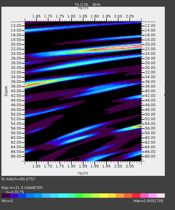
| Estimated Moho Depth: |
21.0 km |
| Estimated Crust Vp/Vs: |
2.02 |
| Assumed Crust Vp: |
6.291 km/s |
| Estimated Crust Vs: |
3.118 km/s |
| Estimated Crust Poisson's Ratio: |
0.34 |
|
| Radial Match: |
90.8757 % |
| Radial Bump: |
400 |
| Transverse Match: |
73.90163 % |
| Transverse Bump: |
400 |
| SOD ConfigId: |
2564 |
| Insert Time: |
2010-03-06 03:28:12.864 +0000 |
| GWidth: |
2.5 |
| Max Bumps: |
400 |
| Tol: |
0.001 |
|

Signal To Noise
| Channel | StoN | STA | LTA |
| TA:I12A: :BHN:20070930T02:20:54.575029Z | 0.79811114 | 6.866185E-8 | 8.603044E-8 |
| TA:I12A: :BHE:20070930T02:20:54.575029Z | 1.3231018 | 1.0418578E-7 | 7.874359E-8 |
| TA:I12A: :BHZ:20070930T02:20:54.575029Z | 2.4566321 | 3.0816628E-7 | 1.2544258E-7 |
| Arrivals |
| Ps | 3.5 SECOND |
| PpPs | 9.9 SECOND |
| PsPs/PpSs | 13 SECOND |


