You are here: Home > Network List > GS - US Geological Survey Networks Stations List
> Station KAN10 Keim Farm, Anthony, KS, USA > Earthquake Result Viewer
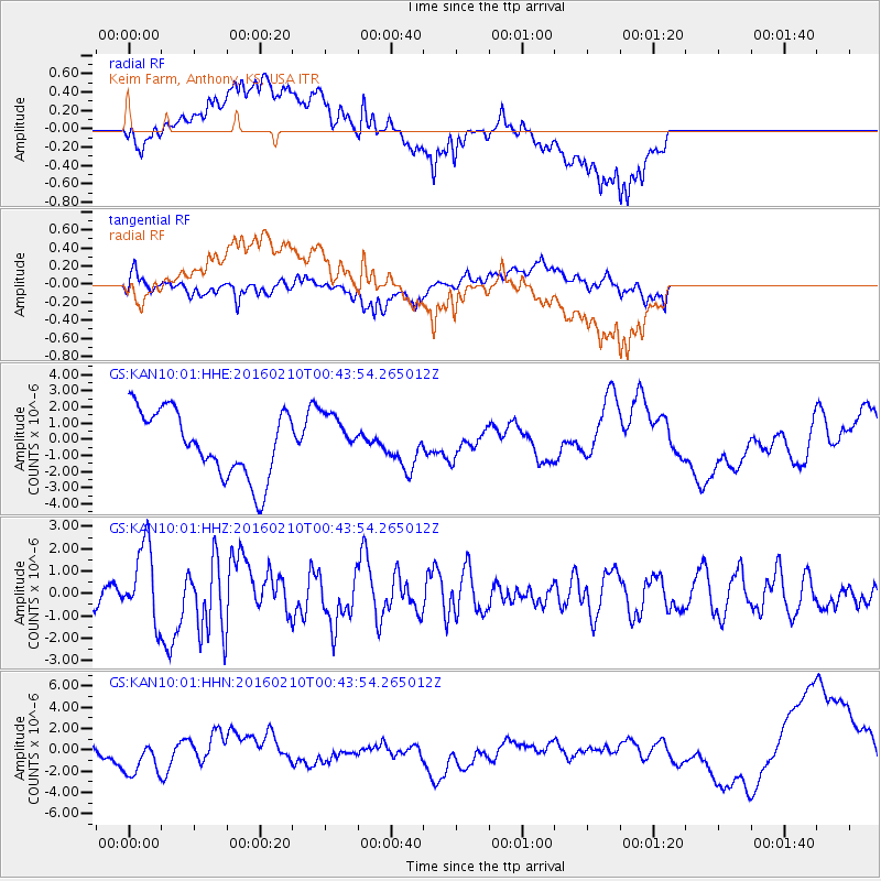
KAN10 Keim Farm, Anthony, KS, USA - Earthquake Result Viewer
*The percent match for this event was below the threshold and hence no stack was calculated.
| Earthquake location: |
Near Coast Of Central Chile |
| Earthquake latitude/longitude: |
-30.6/-71.6 |
| Earthquake time(UTC): |
2016/02/10 (041) 00:33:05 GMT |
| Earthquake Depth: |
32 km |
| Earthquake Magnitude: |
6.3 MWB |
| Earthquake Catalog/Contributor: |
NEIC PDE/NEIC COMCAT |
|
| Network: |
GS US Geological Survey Networks |
| Station: |
KAN10 Keim Farm, Anthony, KS, USA |
| Lat/Lon: |
37.12 N/98.10 W |
| Elevation: |
417 m |
|
| Distance: |
71.8 deg |
| Az: |
337.973 deg |
| Baz: |
156.143 deg |
| Ray Param: |
$rayparam |
*The percent match for this event was below the threshold and hence was not used in the summary stack. |
|
| Radial Match: |
24.677052 % |
| Radial Bump: |
400 |
| Transverse Match: |
59.67636 % |
| Transverse Bump: |
400 |
| SOD ConfigId: |
1427151 |
| Insert Time: |
2016-02-24 00:49:49.906 +0000 |
| GWidth: |
2.5 |
| Max Bumps: |
400 |
| Tol: |
0.001 |
|
Signal To Noise
| Channel | StoN | STA | LTA |
| GS:KAN10:01:HHZ:20160210T00:43:54.265012Z | 2.0205169 | 1.6816903E-6 | 8.32307E-7 |
| GS:KAN10:01:HHN:20160210T00:43:54.265012Z | 0.52170205 | 1.7756978E-6 | 3.4036627E-6 |
| GS:KAN10:01:HHE:20160210T00:43:54.265012Z | 0.7161429 | 1.4685875E-6 | 2.0506905E-6 |
| Arrivals |
| Ps | |
| PpPs | |
| PsPs/PpSs | |


