You are here: Home > Network List > TA - USArray Transportable Network (new EarthScope stations) Stations List
> Station R16K Pilot Point, AK, USA > Earthquake Result Viewer
R16K Pilot Point, AK, USA - Earthquake Result Viewer
| Earthquake location: |
Near Coast Of Chiapas, Mexico |
| Earthquake latitude/longitude: |
15.1/-93.7 |
| Earthquake time(UTC): |
2017/09/08 (251) 04:49:21 GMT |
| Earthquake Depth: |
70 km |
| Earthquake Magnitude: |
8.1 Mww |
| Earthquake Catalog/Contributor: |
NEIC PDE/us |
|
| Network: |
TA USArray Transportable Network (new EarthScope stations) |
| Station: |
R16K Pilot Point, AK, USA |
| Lat/Lon: |
57.57 N/157.57 W |
| Elevation: |
38 m |
|
| Distance: |
63.5 deg |
| Az: |
327.263 deg |
| Baz: |
104.193 deg |
| Ray Param: |
0.059398785 |
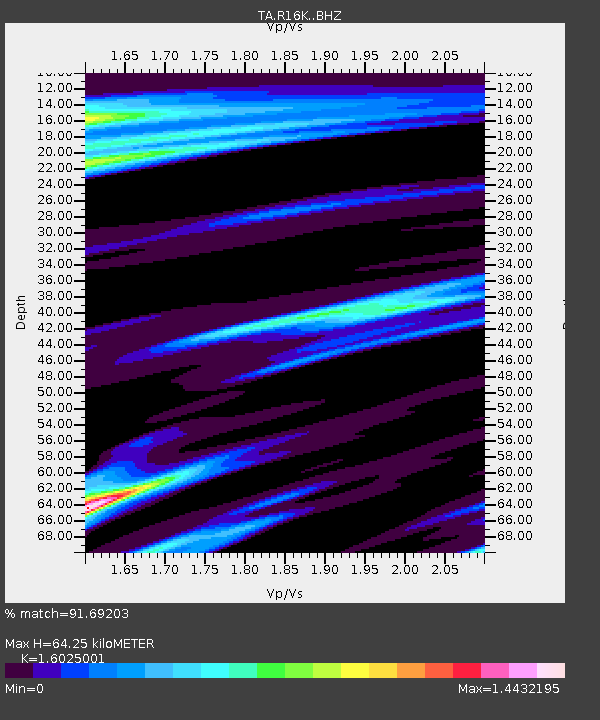
| Estimated Moho Depth: |
64.25 km |
| Estimated Crust Vp/Vs: |
1.60 |
| Assumed Crust Vp: |
6.1 km/s |
| Estimated Crust Vs: |
3.807 km/s |
| Estimated Crust Poisson's Ratio: |
0.18 |
|
| Radial Match: |
91.69203 % |
| Radial Bump: |
400 |
| Transverse Match: |
83.9321 % |
| Transverse Bump: |
369 |
| SOD ConfigId: |
13570011 |
| Insert Time: |
2019-04-28 17:29:24.135 +0000 |
| GWidth: |
2.5 |
| Max Bumps: |
400 |
| Tol: |
0.001 |
|

Signal To Noise
| Channel | StoN | STA | LTA |
| TA:R16K: :BHZ:20170908T04:59:12.725002Z | 12.608413 | 7.3291812E-6 | 5.8129297E-7 |
| TA:R16K: :BHN:20170908T04:59:12.725002Z | 1.1548288 | 1.3436264E-6 | 1.1634854E-6 |
| TA:R16K: :BHE:20170908T04:59:12.725002Z | 2.1599438 | 2.710898E-6 | 1.255078E-6 |
| Arrivals |
| Ps | 6.6 SECOND |
| PpPs | 26 SECOND |
| PsPs/PpSs | 33 SECOND |


