You are here: Home > Network List > TA - USArray Transportable Network (new EarthScope stations) Stations List
> Station S32K Killisnoo, AK, USA > Earthquake Result Viewer
S32K Killisnoo, AK, USA - Earthquake Result Viewer
| Earthquake location: |
Near Coast Of Chiapas, Mexico |
| Earthquake latitude/longitude: |
15.1/-93.7 |
| Earthquake time(UTC): |
2017/09/08 (251) 04:49:21 GMT |
| Earthquake Depth: |
70 km |
| Earthquake Magnitude: |
8.1 Mww |
| Earthquake Catalog/Contributor: |
NEIC PDE/us |
|
| Network: |
TA USArray Transportable Network (new EarthScope stations) |
| Station: |
S32K Killisnoo, AK, USA |
| Lat/Lon: |
57.47 N/134.58 W |
| Elevation: |
26 m |
|
| Distance: |
52.3 deg |
| Az: |
333.445 deg |
| Baz: |
126.938 deg |
| Ray Param: |
0.066681504 |
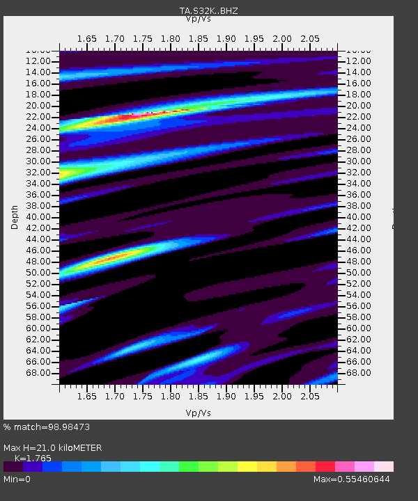
| Estimated Moho Depth: |
21.0 km |
| Estimated Crust Vp/Vs: |
1.76 |
| Assumed Crust Vp: |
6.472 km/s |
| Estimated Crust Vs: |
3.667 km/s |
| Estimated Crust Poisson's Ratio: |
0.26 |
|
| Radial Match: |
98.98473 % |
| Radial Bump: |
242 |
| Transverse Match: |
94.617035 % |
| Transverse Bump: |
400 |
| SOD ConfigId: |
13570011 |
| Insert Time: |
2019-04-28 17:29:29.430 +0000 |
| GWidth: |
2.5 |
| Max Bumps: |
400 |
| Tol: |
0.001 |
|

Signal To Noise
| Channel | StoN | STA | LTA |
| TA:S32K: :BHZ:20170908T04:57:54.52499Z | 3.1464884 | 1.10931E-6 | 3.525549E-7 |
| TA:S32K: :BHN:20170908T04:57:54.52499Z | 1.6546966 | 3.413741E-7 | 2.0630617E-7 |
| TA:S32K: :BHE:20170908T04:57:54.52499Z | 1.888654 | 6.671915E-7 | 3.5326295E-7 |
| Arrivals |
| Ps | 2.6 SECOND |
| PpPs | 8.5 SECOND |
| PsPs/PpSs | 11 SECOND |


