You are here: Home > Network List > TA - USArray Transportable Network (new EarthScope stations) Stations List
> Station S31K Pelican, AK, USA > Earthquake Result Viewer
S31K Pelican, AK, USA - Earthquake Result Viewer
| Earthquake location: |
Near Coast Of Chiapas, Mexico |
| Earthquake latitude/longitude: |
15.1/-93.7 |
| Earthquake time(UTC): |
2017/09/08 (251) 04:49:21 GMT |
| Earthquake Depth: |
70 km |
| Earthquake Magnitude: |
8.1 Mww |
| Earthquake Catalog/Contributor: |
NEIC PDE/us |
|
| Network: |
TA USArray Transportable Network (new EarthScope stations) |
| Station: |
S31K Pelican, AK, USA |
| Lat/Lon: |
57.96 N/136.23 W |
| Elevation: |
34 m |
|
| Distance: |
53.3 deg |
| Az: |
333.287 deg |
| Baz: |
125.446 deg |
| Ray Param: |
0.06601504 |
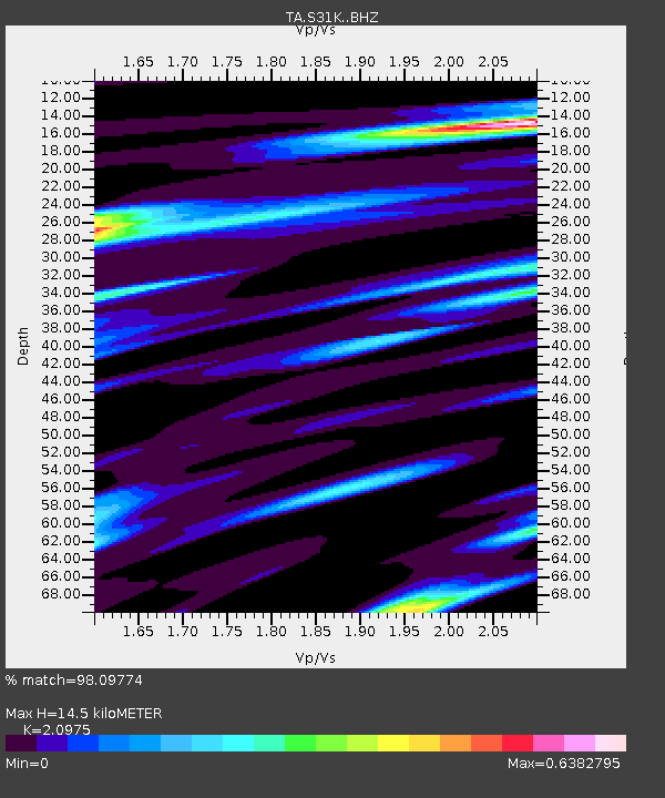
| Estimated Moho Depth: |
14.5 km |
| Estimated Crust Vp/Vs: |
2.10 |
| Assumed Crust Vp: |
6.134 km/s |
| Estimated Crust Vs: |
2.924 km/s |
| Estimated Crust Poisson's Ratio: |
0.35 |
|
| Radial Match: |
98.09774 % |
| Radial Bump: |
303 |
| Transverse Match: |
88.85509 % |
| Transverse Bump: |
400 |
| SOD ConfigId: |
13570011 |
| Insert Time: |
2019-04-28 17:29:30.483 +0000 |
| GWidth: |
2.5 |
| Max Bumps: |
400 |
| Tol: |
0.001 |
|

Signal To Noise
| Channel | StoN | STA | LTA |
| TA:S31K: :BHZ:20170908T04:58:01.949978Z | 3.0703683 | 1.1364943E-6 | 3.701492E-7 |
| TA:S31K: :BHN:20170908T04:58:01.949978Z | 2.512003 | 4.4415498E-7 | 1.7681307E-7 |
| TA:S31K: :BHE:20170908T04:58:01.949978Z | 2.5074263 | 5.591845E-7 | 2.2301134E-7 |
| Arrivals |
| Ps | 2.7 SECOND |
| PpPs | 7.0 SECOND |
| PsPs/PpSs | 9.7 SECOND |


