You are here: Home > Network List > TD - TransAlta Monitoring Network Stations List
> Station TD011 Z > Earthquake Result Viewer
TD011 Z - Earthquake Result Viewer
| Earthquake location: |
Near Coast Of Chiapas, Mexico |
| Earthquake latitude/longitude: |
15.1/-93.7 |
| Earthquake time(UTC): |
2017/09/08 (251) 04:49:21 GMT |
| Earthquake Depth: |
70 km |
| Earthquake Magnitude: |
8.1 Mww |
| Earthquake Catalog/Contributor: |
NEIC PDE/us |
|
| Network: |
TD TransAlta Monitoring Network |
| Station: |
TD011 Z |
| Lat/Lon: |
52.55 N/115.52 W |
| Elevation: |
1103 m |
|
| Distance: |
41.2 deg |
| Az: |
339.865 deg |
| Baz: |
147.004 deg |
| Ray Param: |
0.0737149 |
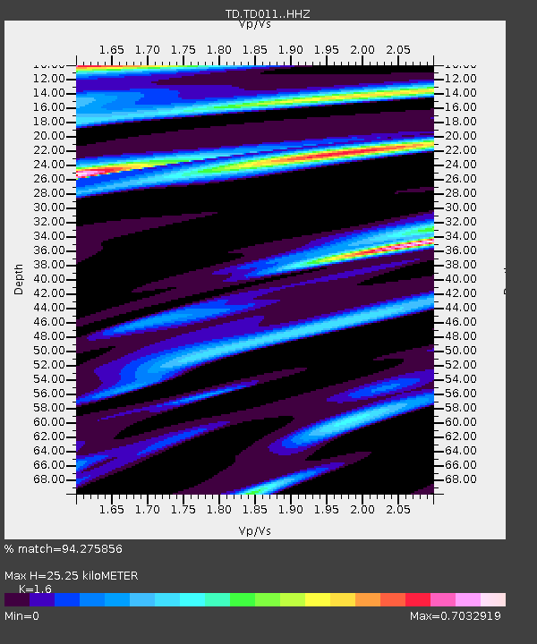
| Estimated Moho Depth: |
25.25 km |
| Estimated Crust Vp/Vs: |
1.60 |
| Assumed Crust Vp: |
6.426 km/s |
| Estimated Crust Vs: |
4.016 km/s |
| Estimated Crust Poisson's Ratio: |
0.18 |
|
| Radial Match: |
94.275856 % |
| Radial Bump: |
400 |
| Transverse Match: |
93.8151 % |
| Transverse Bump: |
323 |
| SOD ConfigId: |
13570011 |
| Insert Time: |
2019-04-28 17:29:38.660 +0000 |
| GWidth: |
2.5 |
| Max Bumps: |
400 |
| Tol: |
0.001 |
|

Signal To Noise
| Channel | StoN | STA | LTA |
| TD:TD011: :HHZ:20170908T04:56:28.499996Z | 37.817314 | 8.270993E-6 | 2.1870916E-7 |
| TD:TD011: :HH1:20170908T04:56:28.499996Z | 6.326415 | 8.93424E-7 | 1.4122121E-7 |
| TD:TD011: :HH2:20170908T04:56:28.499996Z | 20.108044 | 3.8280978E-6 | 1.9037643E-7 |
| Arrivals |
| Ps | 2.5 SECOND |
| PpPs | 9.5 SECOND |
| PsPs/PpSs | 12 SECOND |


