You are here: Home > Network List > UO - University of Oregon Regional Network Stations List
> Station MINN McMinnville, OR, USA > Earthquake Result Viewer
MINN McMinnville, OR, USA - Earthquake Result Viewer
| Earthquake location: |
Near Coast Of Chiapas, Mexico |
| Earthquake latitude/longitude: |
15.1/-93.7 |
| Earthquake time(UTC): |
2017/09/08 (251) 04:49:21 GMT |
| Earthquake Depth: |
70 km |
| Earthquake Magnitude: |
8.1 Mww |
| Earthquake Catalog/Contributor: |
NEIC PDE/us |
|
| Network: |
UO University of Oregon Regional Network |
| Station: |
MINN McMinnville, OR, USA |
| Lat/Lon: |
45.21 N/123.26 W |
| Elevation: |
222 m |
|
| Distance: |
39.0 deg |
| Az: |
326.389 deg |
| Baz: |
130.841 deg |
| Ray Param: |
0.0750103 |
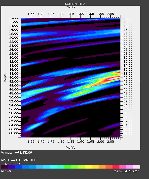
| Estimated Moho Depth: |
40.0 km |
| Estimated Crust Vp/Vs: |
2.08 |
| Assumed Crust Vp: |
6.566 km/s |
| Estimated Crust Vs: |
3.161 km/s |
| Estimated Crust Poisson's Ratio: |
0.35 |
|
| Radial Match: |
94.85109 % |
| Radial Bump: |
348 |
| Transverse Match: |
85.12559 % |
| Transverse Bump: |
400 |
| SOD ConfigId: |
13570011 |
| Insert Time: |
2019-04-28 17:30:06.760 +0000 |
| GWidth: |
2.5 |
| Max Bumps: |
400 |
| Tol: |
0.001 |
|

Signal To Noise
| Channel | StoN | STA | LTA |
| UO:MINN: :HHZ:20170908T04:56:10.157986Z | 8.133482 | 4.2636816E-6 | 5.242136E-7 |
| UO:MINN: :HHN:20170908T04:56:10.157986Z | 4.7559447 | 1.1992466E-6 | 2.521574E-7 |
| UO:MINN: :HHE:20170908T04:56:10.157986Z | 5.7619796 | 1.8089069E-6 | 3.1393844E-7 |
| Arrivals |
| Ps | 7.0 SECOND |
| PpPs | 18 SECOND |
| PsPs/PpSs | 25 SECOND |


