You are here: Home > Network List > TA - USArray Transportable Network (new EarthScope stations) Stations List
> Station I12A Atlanta, ID, USA > Earthquake Result Viewer
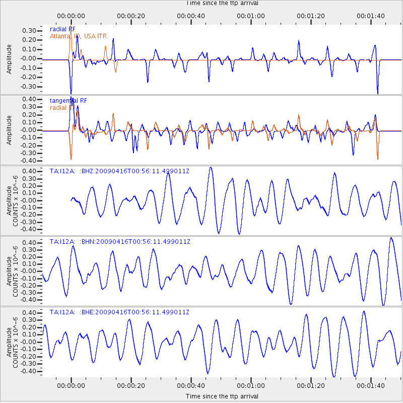
I12A Atlanta, ID, USA - Earthquake Result Viewer
*The percent match for this event was below the threshold and hence no stack was calculated.
| Earthquake location: |
Solomon Islands |
| Earthquake latitude/longitude: |
-6.5/154.2 |
| Earthquake time(UTC): |
2009/04/16 (106) 00:43:20 GMT |
| Earthquake Depth: |
10 km |
| Earthquake Magnitude: |
5.8 MS, 5.3 MB, 5.8 MW, 5.7 MW |
| Earthquake Catalog/Contributor: |
WHDF/NEIC |
|
| Network: |
TA USArray Transportable Network (new EarthScope stations) |
| Station: |
I12A Atlanta, ID, USA |
| Lat/Lon: |
43.79 N/115.13 W |
| Elevation: |
1849 m |
|
| Distance: |
95.0 deg |
| Az: |
46.619 deg |
| Baz: |
265.817 deg |
| Ray Param: |
$rayparam |
*The percent match for this event was below the threshold and hence was not used in the summary stack. |
|
| Radial Match: |
40.925087 % |
| Radial Bump: |
305 |
| Transverse Match: |
49.907326 % |
| Transverse Bump: |
400 |
| SOD ConfigId: |
2658 |
| Insert Time: |
2010-03-06 03:28:34.907 +0000 |
| GWidth: |
2.5 |
| Max Bumps: |
400 |
| Tol: |
0.001 |
|
Signal To Noise
| Channel | StoN | STA | LTA |
| TA:I12A: :BHN:20090416T00:56:11.499011Z | 1.8054574 | 1.969432E-7 | 1.09082166E-7 |
| TA:I12A: :BHE:20090416T00:56:11.499011Z | 0.8258554 | 1.2717884E-7 | 1.539965E-7 |
| TA:I12A: :BHZ:20090416T00:56:11.499011Z | 2.1967545 | 2.426536E-7 | 1.1046004E-7 |
| Arrivals |
| Ps | |
| PpPs | |
| PsPs/PpSs | |


