You are here: Home > Network List > UW - Pacific Northwest Regional Seismic Network Stations List
> Station GNW Green Mountain (BB) > Earthquake Result Viewer
GNW Green Mountain (BB) - Earthquake Result Viewer
| Earthquake location: |
Near Coast Of Chiapas, Mexico |
| Earthquake latitude/longitude: |
15.1/-93.7 |
| Earthquake time(UTC): |
2017/09/08 (251) 04:49:21 GMT |
| Earthquake Depth: |
70 km |
| Earthquake Magnitude: |
8.1 Mww |
| Earthquake Catalog/Contributor: |
NEIC PDE/us |
|
| Network: |
UW Pacific Northwest Regional Seismic Network |
| Station: |
GNW Green Mountain (BB) |
| Lat/Lon: |
47.56 N/122.83 W |
| Elevation: |
160 m |
|
| Distance: |
40.4 deg |
| Az: |
329.438 deg |
| Baz: |
133.504 deg |
| Ray Param: |
0.07422172 |
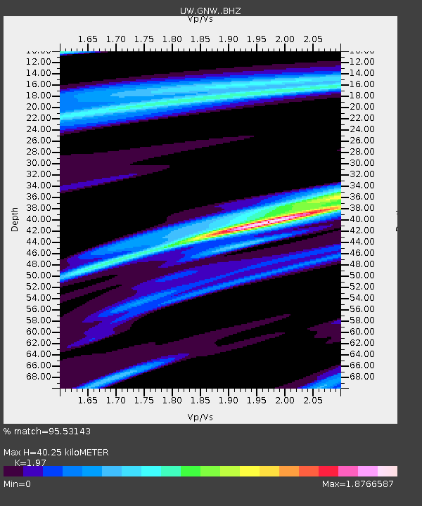
| Estimated Moho Depth: |
40.25 km |
| Estimated Crust Vp/Vs: |
1.97 |
| Assumed Crust Vp: |
6.566 km/s |
| Estimated Crust Vs: |
3.333 km/s |
| Estimated Crust Poisson's Ratio: |
0.33 |
|
| Radial Match: |
95.53143 % |
| Radial Bump: |
349 |
| Transverse Match: |
93.194336 % |
| Transverse Bump: |
343 |
| SOD ConfigId: |
13570011 |
| Insert Time: |
2019-04-28 17:30:20.874 +0000 |
| GWidth: |
2.5 |
| Max Bumps: |
400 |
| Tol: |
0.001 |
|
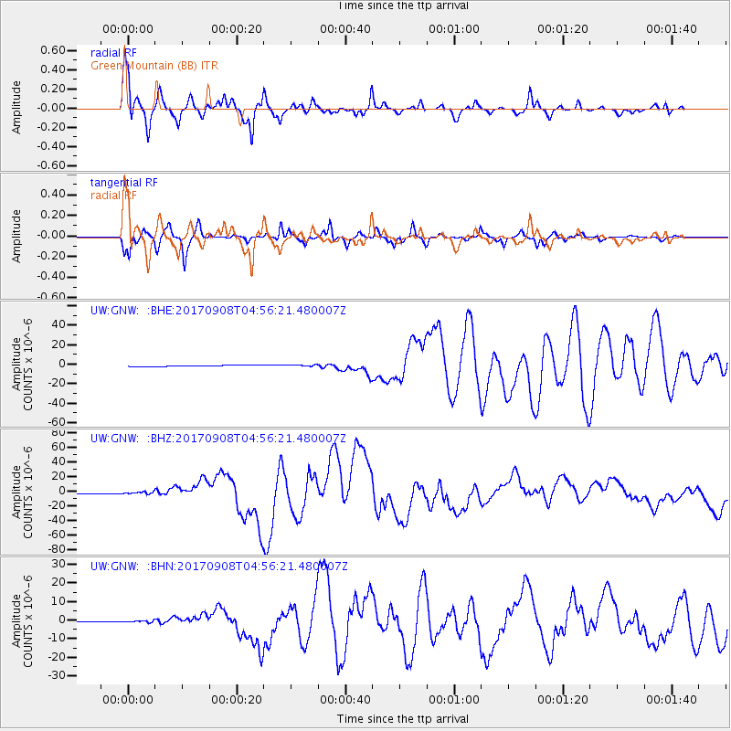
Signal To Noise
| Channel | StoN | STA | LTA |
| UW:GNW: :BHZ:20170908T04:56:21.480007Z | 2.241208 | 1.5084458E-6 | 6.7305035E-7 |
| UW:GNW: :BHN:20170908T04:56:21.480007Z | 1.5937772 | 4.9555615E-7 | 3.1093188E-7 |
| UW:GNW: :BHE:20170908T04:56:21.480007Z | 1.3830991 | 8.326359E-7 | 6.020074E-7 |
| Arrivals |
| Ps | 6.3 SECOND |
| PpPs | 17 SECOND |
| PsPs/PpSs | 23 SECOND |


