You are here: Home > Network List > UW - Pacific Northwest Regional Seismic Network Stations List
> Station LON Longmire CREST broad-band > Earthquake Result Viewer
LON Longmire CREST broad-band - Earthquake Result Viewer
| Earthquake location: |
Near Coast Of Chiapas, Mexico |
| Earthquake latitude/longitude: |
15.1/-93.7 |
| Earthquake time(UTC): |
2017/09/08 (251) 04:49:21 GMT |
| Earthquake Depth: |
70 km |
| Earthquake Magnitude: |
8.1 Mww |
| Earthquake Catalog/Contributor: |
NEIC PDE/us |
|
| Network: |
UW Pacific Northwest Regional Seismic Network |
| Station: |
LON Longmire CREST broad-band |
| Lat/Lon: |
46.75 N/121.81 W |
| Elevation: |
853 m |
|
| Distance: |
39.3 deg |
| Az: |
329.27 deg |
| Baz: |
134.118 deg |
| Ray Param: |
0.07484296 |
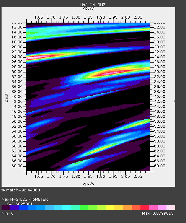
| Estimated Moho Depth: |
24.25 km |
| Estimated Crust Vp/Vs: |
1.60 |
| Assumed Crust Vp: |
6.597 km/s |
| Estimated Crust Vs: |
4.117 km/s |
| Estimated Crust Poisson's Ratio: |
0.18 |
|
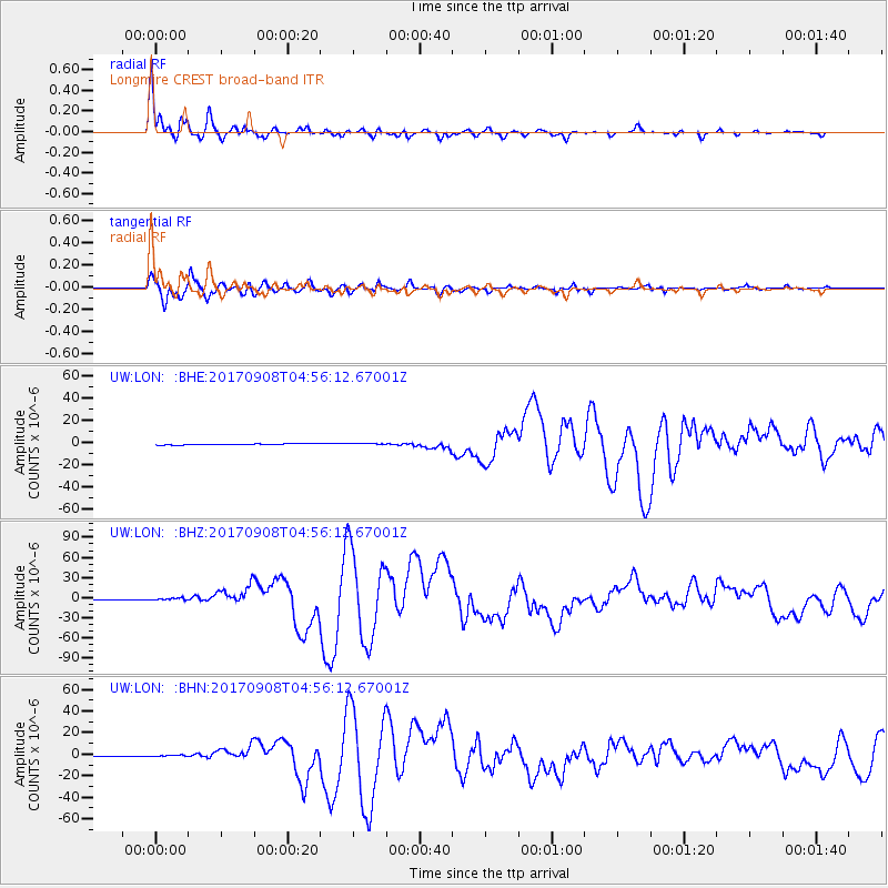
| Radial Match: |
96.44863 % |
| Radial Bump: |
320 |
| Transverse Match: |
93.022354 % |
| Transverse Bump: |
400 |
| SOD ConfigId: |
13570011 |
| Insert Time: |
2019-04-28 17:30:26.947 +0000 |
| GWidth: |
2.5 |
| Max Bumps: |
400 |
| Tol: |
0.001 |
|
Signal To Noise
| Channel | StoN | STA | LTA |
| UW:LON: :BHZ:20170908T04:56:12.67001Z | 1.903965 | 1.2903428E-6 | 6.777135E-7 |
| UW:LON: :BHN:20170908T04:56:12.67001Z | 1.4301765 | 5.7047123E-7 | 3.988817E-7 |
| UW:LON: :BHE:20170908T04:56:12.67001Z | 1.524459 | 6.943951E-7 | 4.5550266E-7 |
| Arrivals |
| Ps | 2.4 SECOND |
| PpPs | 8.8 SECOND |
| PsPs/PpSs | 11 SECOND |


