You are here: Home > Network List > TA - USArray Transportable Network (new EarthScope stations) Stations List
> Station I12A Atlanta, ID, USA > Earthquake Result Viewer
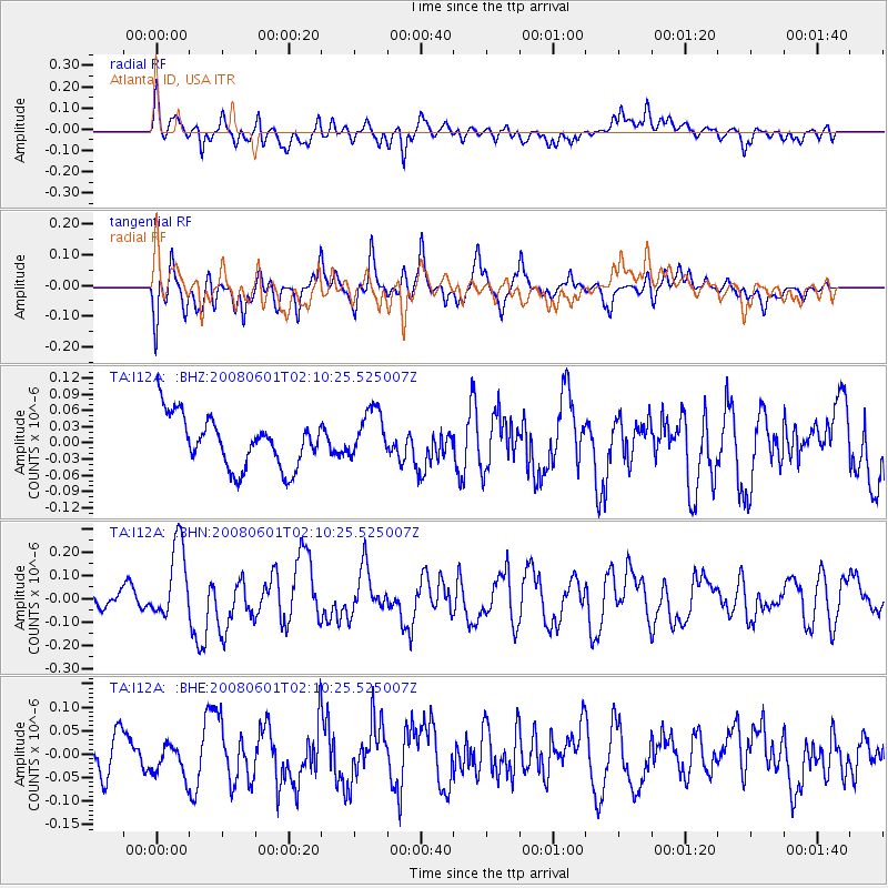
I12A Atlanta, ID, USA - Earthquake Result Viewer
*The percent match for this event was below the threshold and hence no stack was calculated.
| Earthquake location: |
Philippine Islands Region |
| Earthquake latitude/longitude: |
20.1/121.4 |
| Earthquake time(UTC): |
2008/06/01 (153) 01:57:24 GMT |
| Earthquake Depth: |
35 km |
| Earthquake Magnitude: |
6.0 MB, 6.2 MS, 6.3 MW, 6.2 MW |
| Earthquake Catalog/Contributor: |
WHDF/NEIC |
|
| Network: |
TA USArray Transportable Network (new EarthScope stations) |
| Station: |
I12A Atlanta, ID, USA |
| Lat/Lon: |
43.79 N/115.13 W |
| Elevation: |
1849 m |
|
| Distance: |
98.0 deg |
| Az: |
37.579 deg |
| Baz: |
307.687 deg |
| Ray Param: |
$rayparam |
*The percent match for this event was below the threshold and hence was not used in the summary stack. |
|
| Radial Match: |
57.456375 % |
| Radial Bump: |
400 |
| Transverse Match: |
59.859196 % |
| Transverse Bump: |
400 |
| SOD ConfigId: |
2504 |
| Insert Time: |
2010-03-06 03:28:36.764 +0000 |
| GWidth: |
2.5 |
| Max Bumps: |
400 |
| Tol: |
0.001 |
|
Signal To Noise
| Channel | StoN | STA | LTA |
| TA:I12A: :BHN:20080601T02:10:25.525007Z | 2.811812 | 1.6266613E-7 | 5.7850997E-8 |
| TA:I12A: :BHE:20080601T02:10:25.525007Z | 0.53524256 | 3.3630883E-8 | 6.2832974E-8 |
| TA:I12A: :BHZ:20080601T02:10:25.525007Z | 0.97358596 | 4.601608E-8 | 4.726453E-8 |
| Arrivals |
| Ps | |
| PpPs | |
| PsPs/PpSs | |


