You are here: Home > Network List > XV14 - Fault Locations and Alaska Tectonics from Seismicity Stations List
> Station F6TP Tanana River 6, Topo, AK, USA > Earthquake Result Viewer
F6TP Tanana River 6, Topo, AK, USA - Earthquake Result Viewer
| Earthquake location: |
Near Coast Of Chiapas, Mexico |
| Earthquake latitude/longitude: |
15.1/-93.7 |
| Earthquake time(UTC): |
2017/09/08 (251) 04:49:21 GMT |
| Earthquake Depth: |
70 km |
| Earthquake Magnitude: |
8.1 Mww |
| Earthquake Catalog/Contributor: |
NEIC PDE/us |
|
| Network: |
XV Fault Locations and Alaska Tectonics from Seismicity |
| Station: |
F6TP Tanana River 6, Topo, AK, USA |
| Lat/Lon: |
64.87 N/149.56 W |
| Elevation: |
120 m |
|
| Distance: |
62.3 deg |
| Az: |
336.473 deg |
| Baz: |
115.431 deg |
| Ray Param: |
0.060156237 |
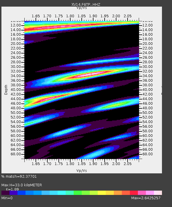
| Estimated Moho Depth: |
33.0 km |
| Estimated Crust Vp/Vs: |
1.89 |
| Assumed Crust Vp: |
6.566 km/s |
| Estimated Crust Vs: |
3.474 km/s |
| Estimated Crust Poisson's Ratio: |
0.31 |
|
| Radial Match: |
92.37701 % |
| Radial Bump: |
382 |
| Transverse Match: |
84.50165 % |
| Transverse Bump: |
345 |
| SOD ConfigId: |
13570011 |
| Insert Time: |
2019-04-28 17:30:58.142 +0000 |
| GWidth: |
2.5 |
| Max Bumps: |
400 |
| Tol: |
0.001 |
|

Signal To Noise
| Channel | StoN | STA | LTA |
| XV:F6TP: :HHZ:20170908T04:59:05.120022Z | 25.99593 | 5.914889E-6 | 2.2753133E-7 |
| XV:F6TP: :HHN:20170908T04:59:05.120022Z | 2.450312 | 7.9108236E-7 | 3.2284964E-7 |
| XV:F6TP: :HHE:20170908T04:59:05.120022Z | 3.3558571 | 1.1816435E-6 | 3.5211374E-7 |
| Arrivals |
| Ps | 4.7 SECOND |
| PpPs | 14 SECOND |
| PsPs/PpSs | 19 SECOND |


