You are here: Home > Network List > XV14 - Fault Locations and Alaska Tectonics from Seismicity Stations List
> Station F5MN Tanana River 5, Old Minto, AK, USA > Earthquake Result Viewer
F5MN Tanana River 5, Old Minto, AK, USA - Earthquake Result Viewer
| Earthquake location: |
Near Coast Of Chiapas, Mexico |
| Earthquake latitude/longitude: |
15.1/-93.7 |
| Earthquake time(UTC): |
2017/09/08 (251) 04:49:21 GMT |
| Earthquake Depth: |
70 km |
| Earthquake Magnitude: |
8.1 Mww |
| Earthquake Catalog/Contributor: |
NEIC PDE/us |
|
| Network: |
XV Fault Locations and Alaska Tectonics from Seismicity |
| Station: |
F5MN Tanana River 5, Old Minto, AK, USA |
| Lat/Lon: |
64.89 N/149.18 W |
| Elevation: |
103 m |
|
| Distance: |
62.1 deg |
| Az: |
336.568 deg |
| Baz: |
115.818 deg |
| Ray Param: |
0.06024785 |
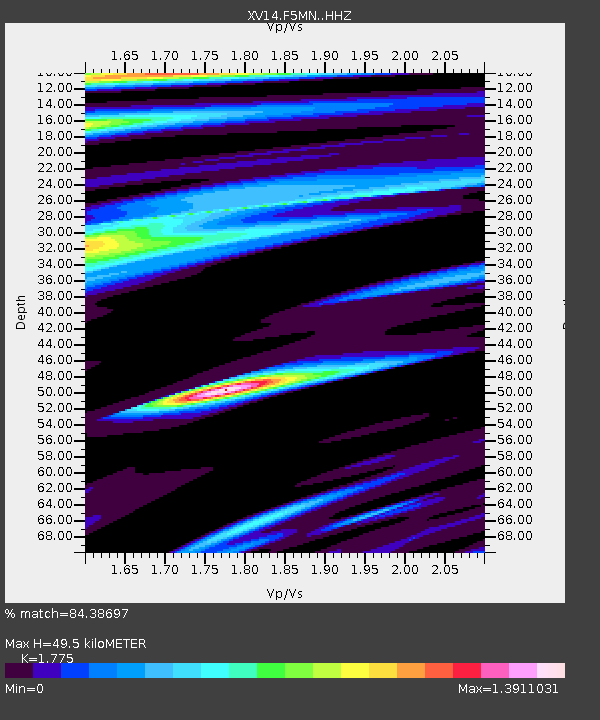
| Estimated Moho Depth: |
49.5 km |
| Estimated Crust Vp/Vs: |
1.77 |
| Assumed Crust Vp: |
6.566 km/s |
| Estimated Crust Vs: |
3.699 km/s |
| Estimated Crust Poisson's Ratio: |
0.27 |
|
| Radial Match: |
84.38697 % |
| Radial Bump: |
400 |
| Transverse Match: |
82.46798 % |
| Transverse Bump: |
400 |
| SOD ConfigId: |
13570011 |
| Insert Time: |
2019-04-28 17:30:58.545 +0000 |
| GWidth: |
2.5 |
| Max Bumps: |
400 |
| Tol: |
0.001 |
|

Signal To Noise
| Channel | StoN | STA | LTA |
| XV:F5MN: :HHZ:20170908T04:59:04.190029Z | 13.024561 | 4.0298232E-6 | 3.0940183E-7 |
| XV:F5MN: :HHN:20170908T04:59:04.190029Z | 1.3709996 | 7.419661E-7 | 5.4118624E-7 |
| XV:F5MN: :HHE:20170908T04:59:04.190029Z | 1.2007337 | 4.1807365E-7 | 3.4818183E-7 |
| Arrivals |
| Ps | 6.1 SECOND |
| PpPs | 20 SECOND |
| PsPs/PpSs | 26 SECOND |


