You are here: Home > Network List > XV14 - Fault Locations and Alaska Tectonics from Seismicity Stations List
> Station FTGH Toghotthele, Parks Hwy, AK, USA > Earthquake Result Viewer
FTGH Toghotthele, Parks Hwy, AK, USA - Earthquake Result Viewer
| Earthquake location: |
Near Coast Of Chiapas, Mexico |
| Earthquake latitude/longitude: |
15.1/-93.7 |
| Earthquake time(UTC): |
2017/09/08 (251) 04:49:21 GMT |
| Earthquake Depth: |
70 km |
| Earthquake Magnitude: |
8.1 Mww |
| Earthquake Catalog/Contributor: |
NEIC PDE/us |
|
| Network: |
XV Fault Locations and Alaska Tectonics from Seismicity |
| Station: |
FTGH Toghotthele, Parks Hwy, AK, USA |
| Lat/Lon: |
64.69 N/148.83 W |
| Elevation: |
286 m |
|
| Distance: |
61.9 deg |
| Az: |
336.444 deg |
| Baz: |
116.079 deg |
| Ray Param: |
0.060393933 |
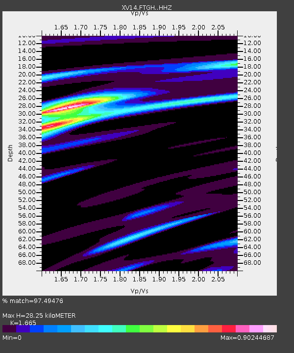
| Estimated Moho Depth: |
28.25 km |
| Estimated Crust Vp/Vs: |
1.66 |
| Assumed Crust Vp: |
6.566 km/s |
| Estimated Crust Vs: |
3.944 km/s |
| Estimated Crust Poisson's Ratio: |
0.22 |
|
| Radial Match: |
97.49476 % |
| Radial Bump: |
227 |
| Transverse Match: |
83.47888 % |
| Transverse Bump: |
400 |
| SOD ConfigId: |
13570011 |
| Insert Time: |
2019-04-28 17:31:03.416 +0000 |
| GWidth: |
2.5 |
| Max Bumps: |
400 |
| Tol: |
0.001 |
|

Signal To Noise
| Channel | StoN | STA | LTA |
| XV:FTGH: :HHZ:20170908T04:59:02.709988Z | 7.759227 | 1.5462057E-6 | 1.9927316E-7 |
| XV:FTGH: :HHN:20170908T04:59:02.709988Z | 4.338934 | 3.5661384E-7 | 8.2189274E-8 |
| XV:FTGH: :HHE:20170908T04:59:02.709988Z | 5.817409 | 7.935129E-7 | 1.3640314E-7 |
| Arrivals |
| Ps | 3.0 SECOND |
| PpPs | 11 SECOND |
| PsPs/PpSs | 14 SECOND |


