You are here: Home > Network List > TA - USArray Transportable Network (new EarthScope stations) Stations List
> Station F20K Avaraart Lake, AK, USA > Earthquake Result Viewer
F20K Avaraart Lake, AK, USA - Earthquake Result Viewer
*The percent match for this event was below the threshold and hence no stack was calculated.
| Earthquake location: |
Near Coast Of Oaxaca, Mexico |
| Earthquake latitude/longitude: |
15.2/-94.3 |
| Earthquake time(UTC): |
2017/09/08 (251) 05:01:33 GMT |
| Earthquake Depth: |
36 km |
| Earthquake Magnitude: |
5.7 mb |
| Earthquake Catalog/Contributor: |
NEIC PDE/us |
|
| Network: |
TA USArray Transportable Network (new EarthScope stations) |
| Station: |
F20K Avaraart Lake, AK, USA |
| Lat/Lon: |
67.05 N/155.73 W |
| Elevation: |
136 m |
|
| Distance: |
65.2 deg |
| Az: |
337.689 deg |
| Baz: |
110.818 deg |
| Ray Param: |
$rayparam |
*The percent match for this event was below the threshold and hence was not used in the summary stack. |
|
| Radial Match: |
68.765884 % |
| Radial Bump: |
315 |
| Transverse Match: |
74.63997 % |
| Transverse Bump: |
275 |
| SOD ConfigId: |
13570011 |
| Insert Time: |
2019-04-28 17:34:38.184 +0000 |
| GWidth: |
2.5 |
| Max Bumps: |
400 |
| Tol: |
0.001 |
|
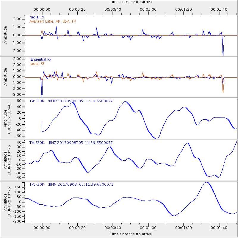
Signal To Noise
| Channel | StoN | STA | LTA |
| TA:F20K: :BHZ:20170908T05:11:39.650007Z | 0.8747575 | 1.6648133E-5 | 1.9031711E-5 |
| TA:F20K: :BHN:20170908T05:11:39.650007Z | 1.252354 | 3.6967762E-5 | 2.951862E-5 |
| TA:F20K: :BHE:20170908T05:11:39.650007Z | 1.9243196 | 6.0011316E-5 | 3.118573E-5 |
| Arrivals |
| Ps | |
| PpPs | |
| PsPs/PpSs | |


