You are here: Home > Network List > TA - USArray Transportable Network (new EarthScope stations) Stations List
> Station H31M Peel River, Yukon, CAN > Earthquake Result Viewer
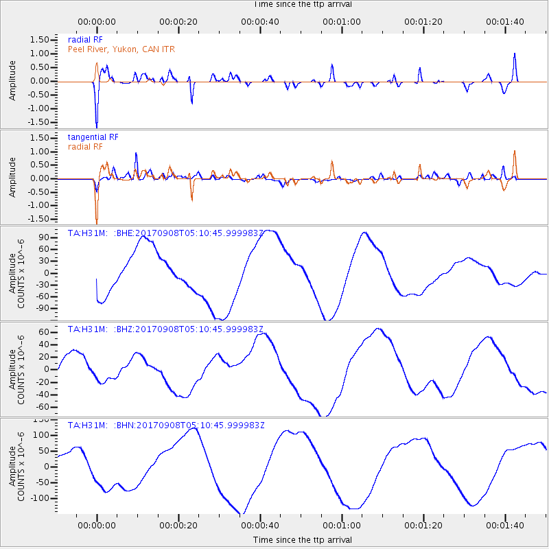
H31M Peel River, Yukon, CAN - Earthquake Result Viewer
*The percent match for this event was below the threshold and hence no stack was calculated.
| Earthquake location: |
Near Coast Of Oaxaca, Mexico |
| Earthquake latitude/longitude: |
15.2/-94.3 |
| Earthquake time(UTC): |
2017/09/08 (251) 05:01:33 GMT |
| Earthquake Depth: |
36 km |
| Earthquake Magnitude: |
5.7 mb |
| Earthquake Catalog/Contributor: |
NEIC PDE/us |
|
| Network: |
TA USArray Transportable Network (new EarthScope stations) |
| Station: |
H31M Peel River, Yukon, CAN |
| Lat/Lon: |
65.81 N/134.34 W |
| Elevation: |
642 m |
|
| Distance: |
57.2 deg |
| Az: |
341.605 deg |
| Baz: |
132.326 deg |
| Ray Param: |
$rayparam |
*The percent match for this event was below the threshold and hence was not used in the summary stack. |
|
| Radial Match: |
50.41035 % |
| Radial Bump: |
400 |
| Transverse Match: |
60.247196 % |
| Transverse Bump: |
400 |
| SOD ConfigId: |
13570011 |
| Insert Time: |
2019-04-28 17:34:45.013 +0000 |
| GWidth: |
2.5 |
| Max Bumps: |
400 |
| Tol: |
0.001 |
|
Signal To Noise
| Channel | StoN | STA | LTA |
| TA:H31M: :BHZ:20170908T05:10:45.999983Z | 0.6692526 | 1.41280025E-5 | 2.111012E-5 |
| TA:H31M: :BHN:20170908T05:10:45.999983Z | 2.0194604 | 6.442823E-5 | 3.1903688E-5 |
| TA:H31M: :BHE:20170908T05:10:45.999983Z | 2.1032333 | 1.0653197E-4 | 5.0651524E-5 |
| Arrivals |
| Ps | |
| PpPs | |
| PsPs/PpSs | |


