You are here: Home > Network List > IU - Global Seismograph Network (GSN - IRIS/USGS) Stations List
> Station RSSD Black Hills, South Dakota, USA > Earthquake Result Viewer
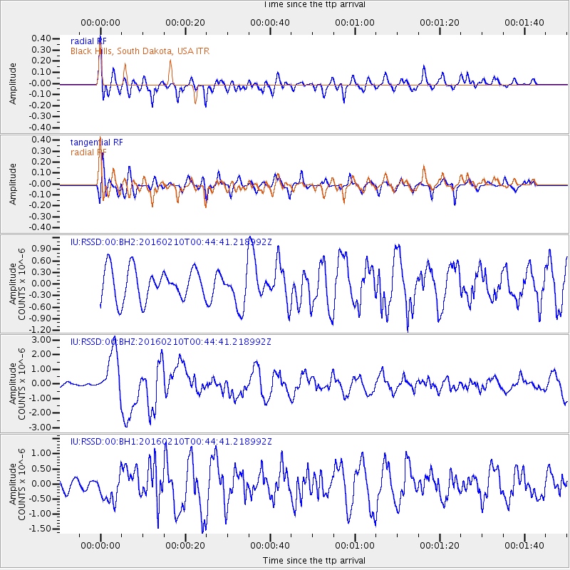
RSSD Black Hills, South Dakota, USA - Earthquake Result Viewer
*The percent match for this event was below the threshold and hence no stack was calculated.
| Earthquake location: |
Near Coast Of Central Chile |
| Earthquake latitude/longitude: |
-30.6/-71.6 |
| Earthquake time(UTC): |
2016/02/10 (041) 00:33:05 GMT |
| Earthquake Depth: |
32 km |
| Earthquake Magnitude: |
6.3 MWB |
| Earthquake Catalog/Contributor: |
NEIC PDE/NEIC COMCAT |
|
| Network: |
IU Global Seismograph Network (GSN - IRIS/USGS) |
| Station: |
RSSD Black Hills, South Dakota, USA |
| Lat/Lon: |
44.12 N/104.04 W |
| Elevation: |
2090 m |
|
| Distance: |
80.1 deg |
| Az: |
336.925 deg |
| Baz: |
152.026 deg |
| Ray Param: |
$rayparam |
*The percent match for this event was below the threshold and hence was not used in the summary stack. |
|
| Radial Match: |
58.001907 % |
| Radial Bump: |
400 |
| Transverse Match: |
64.15985 % |
| Transverse Bump: |
400 |
| SOD ConfigId: |
1427151 |
| Insert Time: |
2016-02-24 00:52:09.014 +0000 |
| GWidth: |
2.5 |
| Max Bumps: |
400 |
| Tol: |
0.001 |
|
Signal To Noise
| Channel | StoN | STA | LTA |
| IU:RSSD:00:BHZ:20160210T00:44:41.218992Z | 4.6516514 | 1.6235883E-6 | 3.4903482E-7 |
| IU:RSSD:00:BH1:20160210T00:44:41.218992Z | 1.9228041 | 4.6535152E-7 | 2.420171E-7 |
| IU:RSSD:00:BH2:20160210T00:44:41.218992Z | 1.2598407 | 5.051218E-7 | 4.00941E-7 |
| Arrivals |
| Ps | |
| PpPs | |
| PsPs/PpSs | |


