You are here: Home > Network List > TA - USArray Transportable Network (new EarthScope stations) Stations List
> Station I12A Atlanta, ID, USA > Earthquake Result Viewer
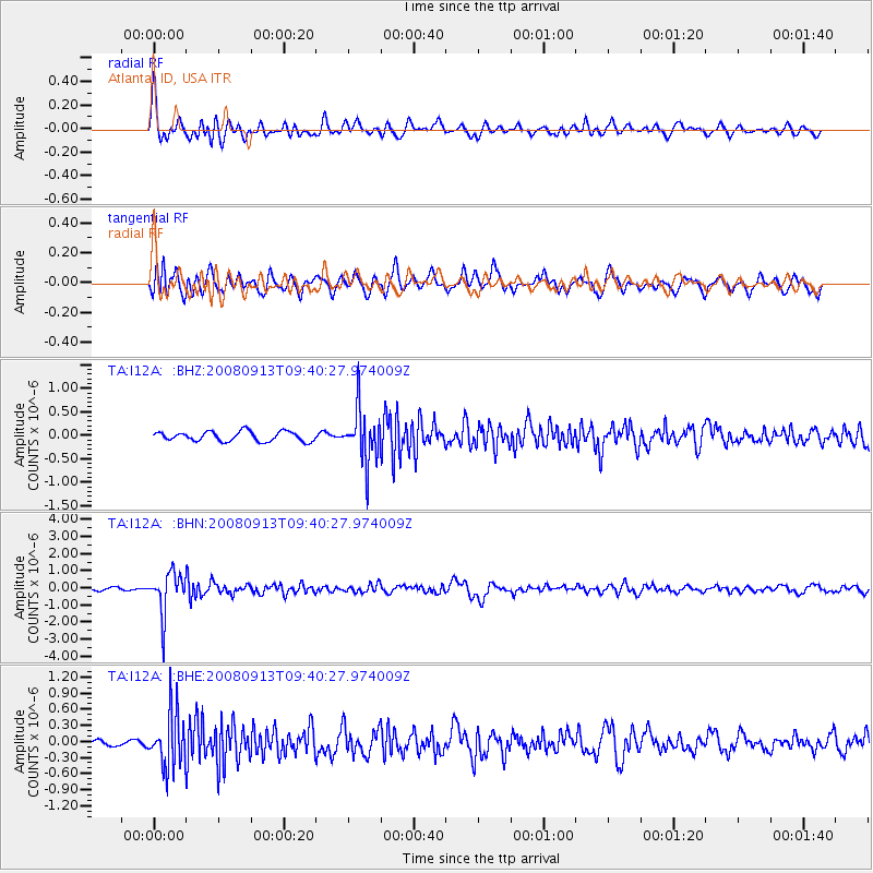
I12A Atlanta, ID, USA - Earthquake Result Viewer
*The percent match for this event was below the threshold and hence no stack was calculated.
| Earthquake location: |
Colombia |
| Earthquake latitude/longitude: |
4.8/-75.5 |
| Earthquake time(UTC): |
2008/09/13 (257) 09:32:01 GMT |
| Earthquake Depth: |
133 km |
| Earthquake Magnitude: |
5.9 MB, 5.7 MW, 5.7 MW |
| Earthquake Catalog/Contributor: |
WHDF/NEIC |
|
| Network: |
TA USArray Transportable Network (new EarthScope stations) |
| Station: |
I12A Atlanta, ID, USA |
| Lat/Lon: |
43.79 N/115.13 W |
| Elevation: |
1849 m |
|
| Distance: |
52.2 deg |
| Az: |
324.233 deg |
| Baz: |
126.451 deg |
| Ray Param: |
$rayparam |
*The percent match for this event was below the threshold and hence was not used in the summary stack. |
|
| Radial Match: |
71.78818 % |
| Radial Bump: |
400 |
| Transverse Match: |
78.41347 % |
| Transverse Bump: |
400 |
| SOD ConfigId: |
2560 |
| Insert Time: |
2010-03-06 03:29:45.928 +0000 |
| GWidth: |
2.5 |
| Max Bumps: |
400 |
| Tol: |
0.001 |
|
Signal To Noise
| Channel | StoN | STA | LTA |
| TA:I12A: :BHN:20080913T09:40:27.974009Z | 11.038258 | 1.2149571E-6 | 1.1006784E-7 |
| TA:I12A: :BHE:20080913T09:40:27.974009Z | 15.126079 | 5.076267E-7 | 3.35597E-8 |
| TA:I12A: :BHZ:20080913T09:40:27.974009Z | 5.4217134 | 5.5679084E-7 | 1.0269647E-7 |
| Arrivals |
| Ps | |
| PpPs | |
| PsPs/PpSs | |


