You are here: Home > Network List > UW - Pacific Northwest Regional Seismic Network Stations List
> Station HOOD Mt Hood Meadows, OR CREST BB SMO > Earthquake Result Viewer
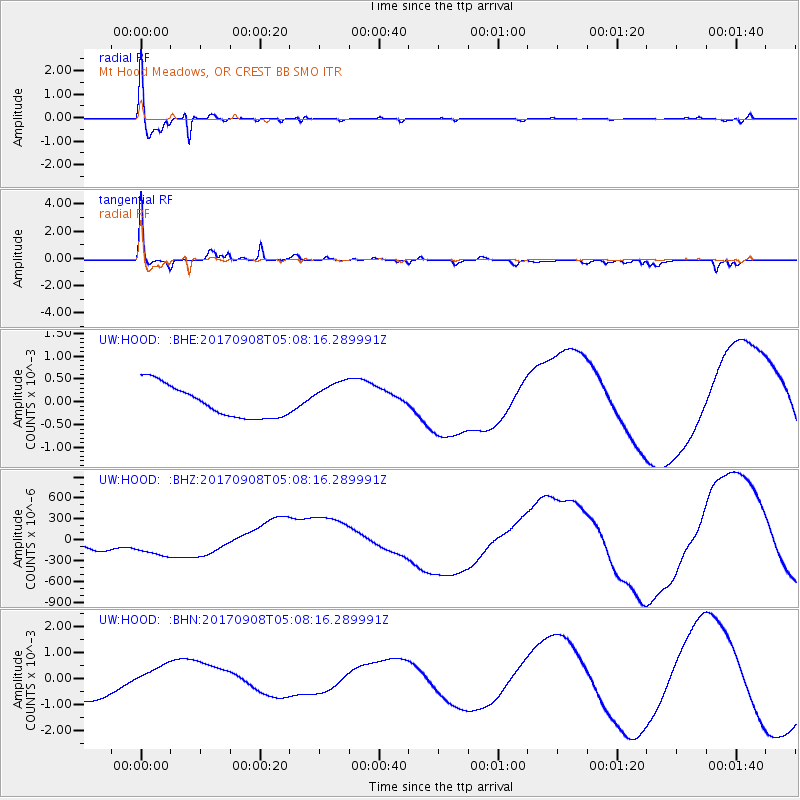
HOOD Mt Hood Meadows, OR CREST BB SMO - Earthquake Result Viewer
*The percent match for this event was below the threshold and hence no stack was calculated.
| Earthquake location: |
Near Coast Of Oaxaca, Mexico |
| Earthquake latitude/longitude: |
15.2/-94.3 |
| Earthquake time(UTC): |
2017/09/08 (251) 05:01:33 GMT |
| Earthquake Depth: |
36 km |
| Earthquake Magnitude: |
5.7 mb |
| Earthquake Catalog/Contributor: |
NEIC PDE/us |
|
| Network: |
UW Pacific Northwest Regional Seismic Network |
| Station: |
HOOD Mt Hood Meadows, OR CREST BB SMO |
| Lat/Lon: |
45.32 N/121.65 W |
| Elevation: |
1520 m |
|
| Distance: |
37.9 deg |
| Az: |
328.107 deg |
| Baz: |
133.688 deg |
| Ray Param: |
$rayparam |
*The percent match for this event was below the threshold and hence was not used in the summary stack. |
|
| Radial Match: |
94.86079 % |
| Radial Bump: |
400 |
| Transverse Match: |
50.59316 % |
| Transverse Bump: |
375 |
| SOD ConfigId: |
13570011 |
| Insert Time: |
2019-04-28 17:35:27.523 +0000 |
| GWidth: |
2.5 |
| Max Bumps: |
400 |
| Tol: |
0.001 |
|
Signal To Noise
| Channel | StoN | STA | LTA |
| UW:HOOD: :BHZ:20170908T05:08:16.289991Z | 1.8855076 | 2.4675054E-4 | 1.308669E-4 |
| UW:HOOD: :BHN:20170908T05:08:16.289991Z | 0.8359276 | 4.9523526E-4 | 5.9243804E-4 |
| UW:HOOD: :BHE:20170908T05:08:16.289991Z | 1.1349624 | 3.9839308E-4 | 3.510187E-4 |
| Arrivals |
| Ps | |
| PpPs | |
| PsPs/PpSs | |


