You are here: Home > Network List > UW - Pacific Northwest Regional Seismic Network Stations List
> Station LCCR Mulino, OR, USA > Earthquake Result Viewer
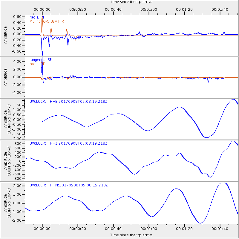
LCCR Mulino, OR, USA - Earthquake Result Viewer
*The percent match for this event was below the threshold and hence no stack was calculated.
| Earthquake location: |
Near Coast Of Oaxaca, Mexico |
| Earthquake latitude/longitude: |
15.2/-94.3 |
| Earthquake time(UTC): |
2017/09/08 (251) 05:01:33 GMT |
| Earthquake Depth: |
36 km |
| Earthquake Magnitude: |
5.7 mb |
| Earthquake Catalog/Contributor: |
NEIC PDE/us |
|
| Network: |
UW Pacific Northwest Regional Seismic Network |
| Station: |
LCCR Mulino, OR, USA |
| Lat/Lon: |
45.21 N/122.48 W |
| Elevation: |
273 m |
|
| Distance: |
38.2 deg |
| Az: |
327.324 deg |
| Baz: |
132.488 deg |
| Ray Param: |
$rayparam |
*The percent match for this event was below the threshold and hence was not used in the summary stack. |
|
| Radial Match: |
67.20959 % |
| Radial Bump: |
400 |
| Transverse Match: |
26.682682 % |
| Transverse Bump: |
400 |
| SOD ConfigId: |
13570011 |
| Insert Time: |
2019-04-28 17:35:29.066 +0000 |
| GWidth: |
2.5 |
| Max Bumps: |
400 |
| Tol: |
0.001 |
|
Signal To Noise
| Channel | StoN | STA | LTA |
| UW:LCCR: :HHZ:20170908T05:08:19.218Z | 2.177479 | 1.20234894E-4 | 5.521748E-5 |
| UW:LCCR: :HHN:20170908T05:08:19.218Z | 1.310222 | 6.2257954E-4 | 4.7517105E-4 |
| UW:LCCR: :HHE:20170908T05:08:19.218Z | 0.71899927 | 2.6620418E-4 | 3.7024263E-4 |
| Arrivals |
| Ps | |
| PpPs | |
| PsPs/PpSs | |


