You are here: Home > Network List > CA - Catalan Seismic Network Stations List
> Station CGAR Garraf > Earthquake Result Viewer
CGAR Garraf - Earthquake Result Viewer
| Earthquake location: |
Near Coast Of Oaxaca, Mexico |
| Earthquake latitude/longitude: |
15.6/-94.6 |
| Earthquake time(UTC): |
2017/09/08 (251) 05:17:43 GMT |
| Earthquake Depth: |
51 km |
| Earthquake Magnitude: |
5.3 mb |
| Earthquake Catalog/Contributor: |
NEIC PDE/us |
|
| Network: |
CA Catalan Seismic Network |
| Station: |
CGAR Garraf |
| Lat/Lon: |
41.29 N/1.91 E |
| Elevation: |
584 m |
|
| Distance: |
84.6 deg |
| Az: |
48.765 deg |
| Baz: |
285.887 deg |
| Ray Param: |
0.04524911 |
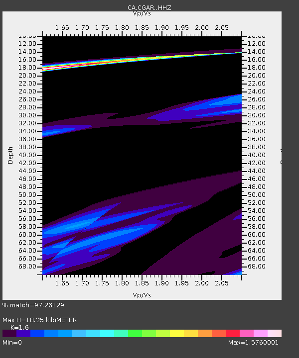
| Estimated Moho Depth: |
18.25 km |
| Estimated Crust Vp/Vs: |
1.60 |
| Assumed Crust Vp: |
6.391 km/s |
| Estimated Crust Vs: |
3.994 km/s |
| Estimated Crust Poisson's Ratio: |
0.18 |
|
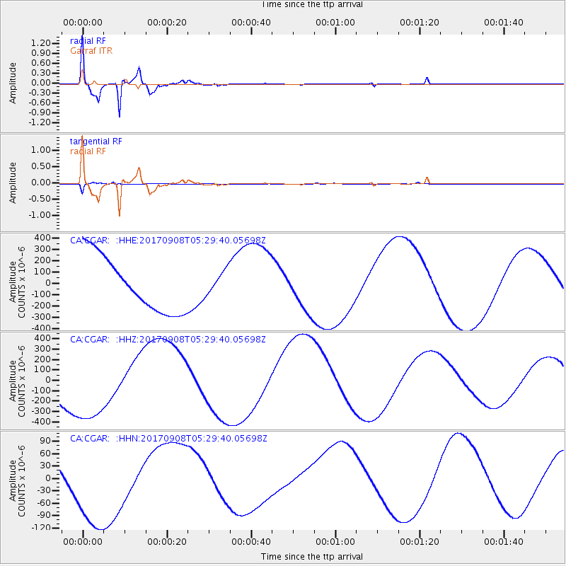
| Radial Match: |
97.26129 % |
| Radial Bump: |
400 |
| Transverse Match: |
72.57257 % |
| Transverse Bump: |
178 |
| SOD ConfigId: |
13570011 |
| Insert Time: |
2019-04-28 17:36:49.732 +0000 |
| GWidth: |
2.5 |
| Max Bumps: |
400 |
| Tol: |
0.001 |
|
Signal To Noise
| Channel | StoN | STA | LTA |
| CA:CGAR: :HHZ:20170908T05:29:40.05698Z | 2.9479325 | 4.588882E-4 | 1.5566441E-4 |
| CA:CGAR: :HHN:20170908T05:29:40.05698Z | 1.8062233 | 1.285447E-4 | 7.116768E-5 |
| CA:CGAR: :HHE:20170908T05:29:40.05698Z | 0.44425127 | 1.0639914E-4 | 2.3950216E-4 |
| Arrivals |
| Ps | 1.8 SECOND |
| PpPs | 7.2 SECOND |
| PsPs/PpSs | 9.0 SECOND |


