You are here: Home > Network List > CH - Switzerland Seismological Network Stations List
> Station SENIN Lac Selin/Sanetsch > Earthquake Result Viewer
SENIN Lac Selin/Sanetsch - Earthquake Result Viewer
| Earthquake location: |
Near Coast Of Oaxaca, Mexico |
| Earthquake latitude/longitude: |
15.6/-94.6 |
| Earthquake time(UTC): |
2017/09/08 (251) 05:17:43 GMT |
| Earthquake Depth: |
51 km |
| Earthquake Magnitude: |
5.3 mb |
| Earthquake Catalog/Contributor: |
NEIC PDE/us |
|
| Network: |
CH Switzerland Seismological Network |
| Station: |
SENIN Lac Selin/Sanetsch |
| Lat/Lon: |
46.36 N/7.30 E |
| Elevation: |
2035 m |
|
| Distance: |
86.8 deg |
| Az: |
42.746 deg |
| Baz: |
289.161 deg |
| Ray Param: |
0.04367546 |
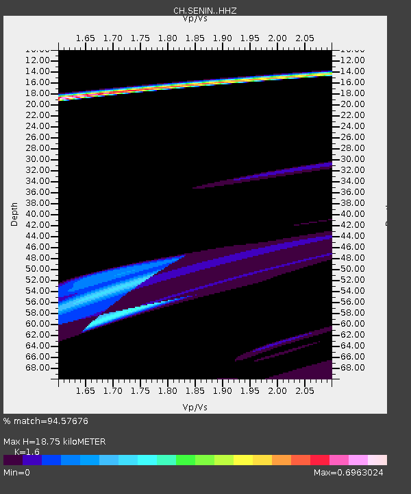
| Estimated Moho Depth: |
18.75 km |
| Estimated Crust Vp/Vs: |
1.60 |
| Assumed Crust Vp: |
6.276 km/s |
| Estimated Crust Vs: |
3.922 km/s |
| Estimated Crust Poisson's Ratio: |
0.18 |
|
| Radial Match: |
94.57676 % |
| Radial Bump: |
400 |
| Transverse Match: |
68.99732 % |
| Transverse Bump: |
400 |
| SOD ConfigId: |
13570011 |
| Insert Time: |
2019-04-28 17:37:09.652 +0000 |
| GWidth: |
2.5 |
| Max Bumps: |
400 |
| Tol: |
0.001 |
|
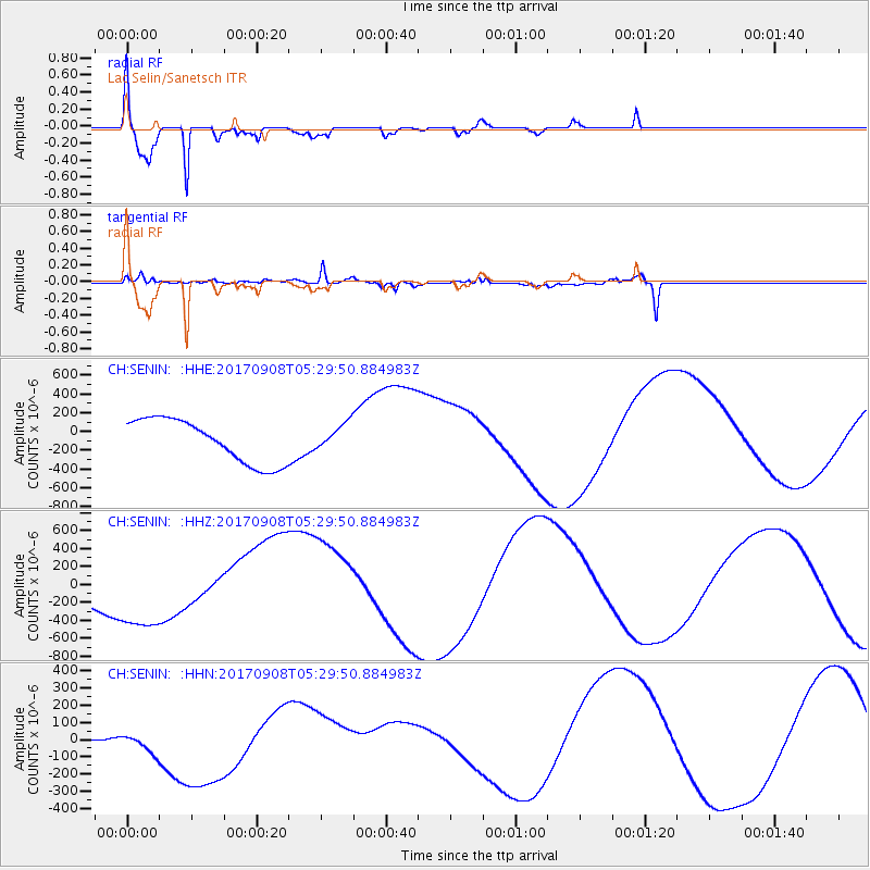
Signal To Noise
| Channel | StoN | STA | LTA |
| CH:SENIN: :HHZ:20170908T05:29:50.884983Z | 3.3600764 | 5.4610503E-4 | 1.6252756E-4 |
| CH:SENIN: :HHN:20170908T05:29:50.884983Z | 1.2765685 | 9.932707E-5 | 7.780787E-5 |
| CH:SENIN: :HHE:20170908T05:29:50.884983Z | 0.59643763 | 1.3843877E-4 | 2.3210939E-4 |
| Arrivals |
| Ps | 1.8 SECOND |
| PpPs | 7.6 SECOND |
| PsPs/PpSs | 9.4 SECOND |


