You are here: Home > Network List > TA - USArray Transportable Network (new EarthScope stations) Stations List
> Station C18K Utukok River, AK, USA > Earthquake Result Viewer
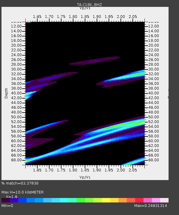
C18K Utukok River, AK, USA - Earthquake Result Viewer
| Earthquake location: |
Near Coast Of Oaxaca, Mexico |
| Earthquake latitude/longitude: |
15.6/-94.6 |
| Earthquake time(UTC): |
2017/09/08 (251) 05:17:43 GMT |
| Earthquake Depth: |
51 km |
| Earthquake Magnitude: |
5.3 mb |
| Earthquake Catalog/Contributor: |
NEIC PDE/us |
|
| Network: |
TA USArray Transportable Network (new EarthScope stations) |
| Station: |
C18K Utukok River, AK, USA |
| Lat/Lon: |
68.65 N/161.19 W |
| Elevation: |
845 m |
|
| Distance: |
67.2 deg |
| Az: |
338.606 deg |
| Baz: |
106.263 deg |
| Ray Param: |
0.057036646 |
| Estimated Moho Depth: |
10.0 km |
| Estimated Crust Vp/Vs: |
1.60 |
| Assumed Crust Vp: |
5.906 km/s |
| Estimated Crust Vs: |
3.692 km/s |
| Estimated Crust Poisson's Ratio: |
0.18 |
|
| Radial Match: |
83.37938 % |
| Radial Bump: |
400 |
| Transverse Match: |
60.958664 % |
| Transverse Bump: |
326 |
| SOD ConfigId: |
13570011 |
| Insert Time: |
2019-04-28 17:39:07.929 +0000 |
| GWidth: |
2.5 |
| Max Bumps: |
400 |
| Tol: |
0.001 |
|

Signal To Noise
| Channel | StoN | STA | LTA |
| TA:C18K: :BHZ:20170908T05:28:00.774998Z | 0.9128464 | 4.4226306E-4 | 4.8448791E-4 |
| TA:C18K: :BHN:20170908T05:28:00.774998Z | 2.601318 | 8.0505724E-4 | 3.0948053E-4 |
| TA:C18K: :BHE:20170908T05:28:00.774998Z | 0.74468935 | 1.692701E-4 | 2.2730297E-4 |
| Arrivals |
| Ps | 1.1 SECOND |
| PpPs | 4.2 SECOND |
| PsPs/PpSs | 5.3 SECOND |


