You are here: Home > Network List > TA - USArray Transportable Network (new EarthScope stations) Stations List
> Station F26K Sheenjek River, AK, USA > Earthquake Result Viewer
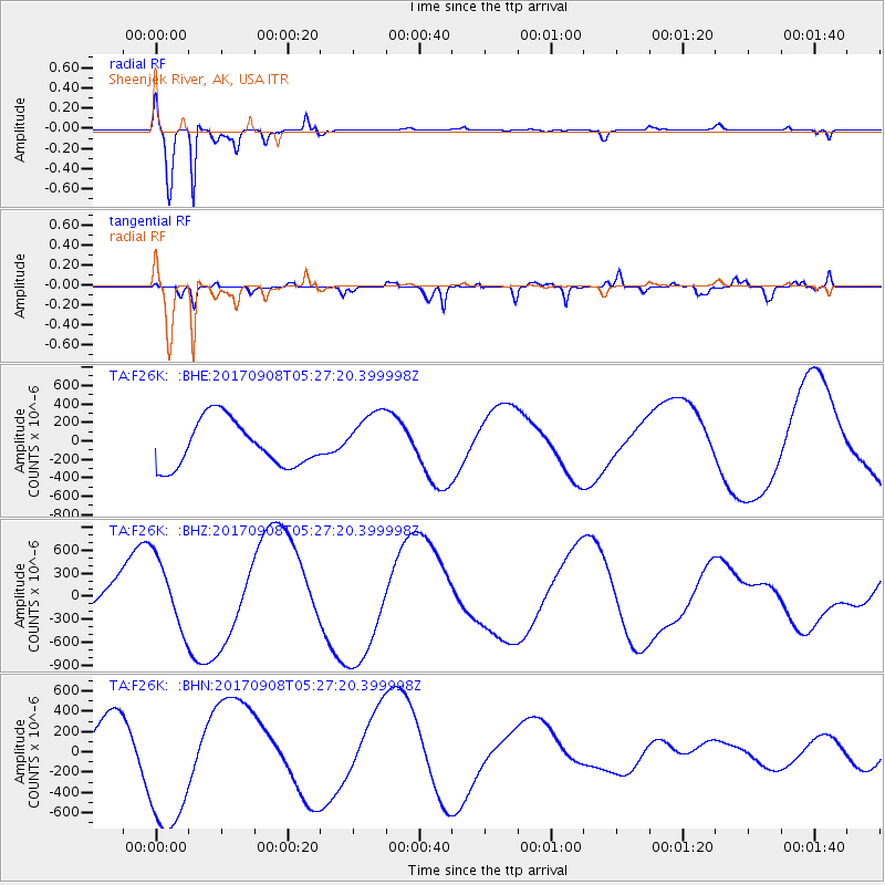
F26K Sheenjek River, AK, USA - Earthquake Result Viewer
*The percent match for this event was below the threshold and hence no stack was calculated.
| Earthquake location: |
Near Coast Of Oaxaca, Mexico |
| Earthquake latitude/longitude: |
15.6/-94.6 |
| Earthquake time(UTC): |
2017/09/08 (251) 05:17:43 GMT |
| Earthquake Depth: |
51 km |
| Earthquake Magnitude: |
5.3 mb |
| Earthquake Catalog/Contributor: |
NEIC PDE/us |
|
| Network: |
TA USArray Transportable Network (new EarthScope stations) |
| Station: |
F26K Sheenjek River, AK, USA |
| Lat/Lon: |
67.69 N/144.15 W |
| Elevation: |
683 m |
|
| Distance: |
61.0 deg |
| Az: |
340.589 deg |
| Baz: |
122.96 deg |
| Ray Param: |
$rayparam |
*The percent match for this event was below the threshold and hence was not used in the summary stack. |
|
| Radial Match: |
97.326645 % |
| Radial Bump: |
320 |
| Transverse Match: |
52.649693 % |
| Transverse Bump: |
340 |
| SOD ConfigId: |
13570011 |
| Insert Time: |
2019-04-28 17:39:15.404 +0000 |
| GWidth: |
2.5 |
| Max Bumps: |
400 |
| Tol: |
0.001 |
|
Signal To Noise
| Channel | StoN | STA | LTA |
| TA:F26K: :BHZ:20170908T05:27:20.399998Z | 3.2368155 | 4.6339145E-4 | 1.4316276E-4 |
| TA:F26K: :BHN:20170908T05:27:20.399998Z | 2.3301845 | 6.740439E-4 | 2.8926632E-4 |
| TA:F26K: :BHE:20170908T05:27:20.399998Z | 1.1843351 | 2.9724673E-4 | 2.5098195E-4 |
| Arrivals |
| Ps | |
| PpPs | |
| PsPs/PpSs | |


