You are here: Home > Network List > TA - USArray Transportable Network (new EarthScope stations) Stations List
> Station G31M Satah River, YT, CAN > Earthquake Result Viewer
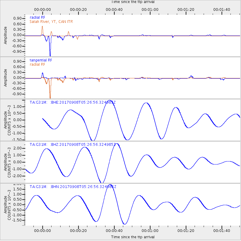
G31M Satah River, YT, CAN - Earthquake Result Viewer
*The percent match for this event was below the threshold and hence no stack was calculated.
| Earthquake location: |
Near Coast Of Oaxaca, Mexico |
| Earthquake latitude/longitude: |
15.6/-94.6 |
| Earthquake time(UTC): |
2017/09/08 (251) 05:17:43 GMT |
| Earthquake Depth: |
51 km |
| Earthquake Magnitude: |
5.3 mb |
| Earthquake Catalog/Contributor: |
NEIC PDE/us |
|
| Network: |
TA USArray Transportable Network (new EarthScope stations) |
| Station: |
G31M Satah River, YT, CAN |
| Lat/Lon: |
66.92 N/134.27 W |
| Elevation: |
61 m |
|
| Distance: |
57.5 deg |
| Az: |
342.625 deg |
| Baz: |
133.107 deg |
| Ray Param: |
$rayparam |
*The percent match for this event was below the threshold and hence was not used in the summary stack. |
|
| Radial Match: |
98.73081 % |
| Radial Bump: |
177 |
| Transverse Match: |
60.43043 % |
| Transverse Bump: |
400 |
| SOD ConfigId: |
13570011 |
| Insert Time: |
2019-04-28 17:39:17.808 +0000 |
| GWidth: |
2.5 |
| Max Bumps: |
400 |
| Tol: |
0.001 |
|
Signal To Noise
| Channel | StoN | STA | LTA |
| TA:G31M: :BHZ:20170908T05:26:56.324985Z | 2.0778368 | 0.0018887371 | 9.089921E-4 |
| TA:G31M: :BHN:20170908T05:26:56.324985Z | 0.63387424 | 3.87536E-4 | 6.1137683E-4 |
| TA:G31M: :BHE:20170908T05:26:56.324985Z | 1.8101536 | 8.8422955E-4 | 4.884832E-4 |
| Arrivals |
| Ps | |
| PpPs | |
| PsPs/PpSs | |


