You are here: Home > Network List > TA - USArray Transportable Network (new EarthScope stations) Stations List
> Station J26L Joseph Creek, AK, USA > Earthquake Result Viewer
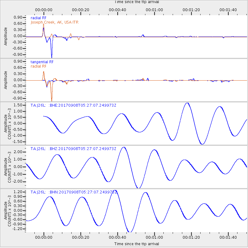
J26L Joseph Creek, AK, USA - Earthquake Result Viewer
*The percent match for this event was below the threshold and hence no stack was calculated.
| Earthquake location: |
Near Coast Of Oaxaca, Mexico |
| Earthquake latitude/longitude: |
15.6/-94.6 |
| Earthquake time(UTC): |
2017/09/08 (251) 05:17:43 GMT |
| Earthquake Depth: |
51 km |
| Earthquake Magnitude: |
5.3 mb |
| Earthquake Catalog/Contributor: |
NEIC PDE/us |
|
| Network: |
TA USArray Transportable Network (new EarthScope stations) |
| Station: |
J26L Joseph Creek, AK, USA |
| Lat/Lon: |
64.50 N/143.56 W |
| Elevation: |
1144 m |
|
| Distance: |
59.1 deg |
| Az: |
337.612 deg |
| Baz: |
122.004 deg |
| Ray Param: |
$rayparam |
*The percent match for this event was below the threshold and hence was not used in the summary stack. |
|
| Radial Match: |
97.57984 % |
| Radial Bump: |
266 |
| Transverse Match: |
84.4299 % |
| Transverse Bump: |
282 |
| SOD ConfigId: |
13570011 |
| Insert Time: |
2019-04-28 17:39:25.124 +0000 |
| GWidth: |
2.5 |
| Max Bumps: |
400 |
| Tol: |
0.001 |
|
Signal To Noise
| Channel | StoN | STA | LTA |
| TA:J26L: :BHZ:20170908T05:27:07.249973Z | 1.0782905 | 8.8423886E-4 | 8.2003773E-4 |
| TA:J26L: :BHN:20170908T05:27:07.249973Z | 1.6163493 | 8.363053E-4 | 5.174038E-4 |
| TA:J26L: :BHE:20170908T05:27:07.249973Z | 1.6584167 | 7.8706647E-4 | 4.745891E-4 |
| Arrivals |
| Ps | |
| PpPs | |
| PsPs/PpSs | |


