You are here: Home > Network List > UW - Pacific Northwest Regional Seismic Network Stations List
> Station UMAT Pilot Rock, OR, USA > Earthquake Result Viewer
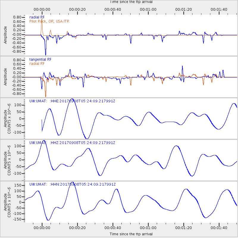
UMAT Pilot Rock, OR, USA - Earthquake Result Viewer
*The percent match for this event was below the threshold and hence no stack was calculated.
| Earthquake location: |
Near Coast Of Oaxaca, Mexico |
| Earthquake latitude/longitude: |
15.6/-94.6 |
| Earthquake time(UTC): |
2017/09/08 (251) 05:17:43 GMT |
| Earthquake Depth: |
51 km |
| Earthquake Magnitude: |
5.3 mb |
| Earthquake Catalog/Contributor: |
NEIC PDE/us |
|
| Network: |
UW Pacific Northwest Regional Seismic Network |
| Station: |
UMAT Pilot Rock, OR, USA |
| Lat/Lon: |
45.29 N/118.96 W |
| Elevation: |
1318 m |
|
| Distance: |
36.0 deg |
| Az: |
330.302 deg |
| Baz: |
137.436 deg |
| Ray Param: |
$rayparam |
*The percent match for this event was below the threshold and hence was not used in the summary stack. |
|
| Radial Match: |
65.310165 % |
| Radial Bump: |
247 |
| Transverse Match: |
67.02753 % |
| Transverse Bump: |
360 |
| SOD ConfigId: |
13570011 |
| Insert Time: |
2019-04-28 17:39:56.794 +0000 |
| GWidth: |
2.5 |
| Max Bumps: |
400 |
| Tol: |
0.001 |
|
Signal To Noise
| Channel | StoN | STA | LTA |
| UW:UMAT: :HHZ:20170908T05:24:09.217991Z | 2.8556209 | 1.1370133E-4 | 3.9816674E-5 |
| UW:UMAT: :HHN:20170908T05:24:09.217991Z | 2.9042487 | 1.0694681E-4 | 3.682426E-5 |
| UW:UMAT: :HHE:20170908T05:24:09.217991Z | 0.37038684 | 3.1585307E-5 | 8.527653E-5 |
| Arrivals |
| Ps | |
| PpPs | |
| PsPs/PpSs | |


