You are here: Home > Network List > IU - Global Seismograph Network (GSN - IRIS/USGS) Stations List
> Station GRFO Grafenberg, Germany > Earthquake Result Viewer
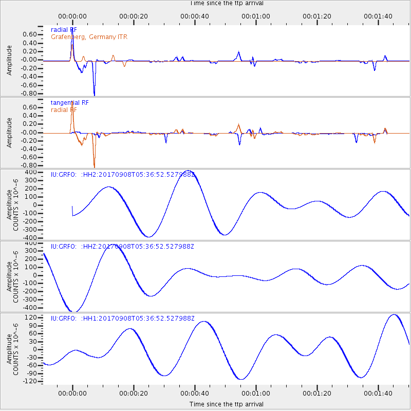
GRFO Grafenberg, Germany - Earthquake Result Viewer

| Earthquake location: |
Near Coast Of Oaxaca, Mexico |
| Earthquake latitude/longitude: |
15.2/-94.6 |
| Earthquake time(UTC): |
2017/09/08 (251) 05:24:36 GMT |
| Earthquake Depth: |
49 km |
| Earthquake Magnitude: |
5.2 mb |
| Earthquake Catalog/Contributor: |
NEIC PDE/us |
|
| Network: |
IU Global Seismograph Network (GSN - IRIS/USGS) |
| Station: |
GRFO Grafenberg, Germany |
| Lat/Lon: |
49.69 N/11.22 E |
| Elevation: |
384 m |
|
| Distance: |
88.4 deg |
| Az: |
38.688 deg |
| Baz: |
291.682 deg |
| Ray Param: |
0.042506836 |
| Estimated Moho Depth: |
14.25 km |
| Estimated Crust Vp/Vs: |
1.62 |
| Assumed Crust Vp: |
6.182 km/s |
| Estimated Crust Vs: |
3.828 km/s |
| Estimated Crust Poisson's Ratio: |
0.19 |
|
| Radial Match: |
97.244354 % |
| Radial Bump: |
321 |
| Transverse Match: |
84.847916 % |
| Transverse Bump: |
374 |
| SOD ConfigId: |
13570011 |
| Insert Time: |
2019-04-28 17:42:42.927 +0000 |
| GWidth: |
2.5 |
| Max Bumps: |
400 |
| Tol: |
0.001 |
|
Signal To Noise
| Channel | StoN | STA | LTA |
| IU:GRFO: :HHZ:20170908T05:36:52.527988Z | 2.1643476 | 4.5068457E-4 | 2.0823114E-4 |
| IU:GRFO: :HH1:20170908T05:36:52.527988Z | 0.13056782 | 9.231623E-6 | 7.070367E-5 |
| IU:GRFO: :HH2:20170908T05:36:52.527988Z | 0.9692386 | 1.7801781E-4 | 1.836677E-4 |
| Arrivals |
| Ps | 1.4 SECOND |
| PpPs | 5.9 SECOND |
| PsPs/PpSs | 7.3 SECOND |


