You are here: Home > Network List > TA - USArray Transportable Network (new EarthScope stations) Stations List
> Station I12A Atlanta, ID, USA > Earthquake Result Viewer
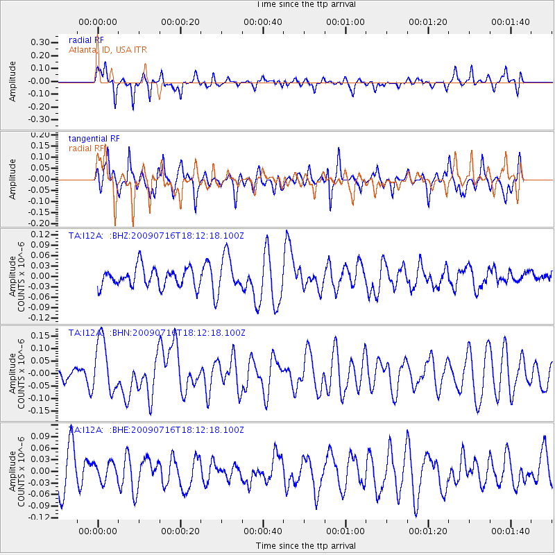
I12A Atlanta, ID, USA - Earthquake Result Viewer
*The percent match for this event was below the threshold and hence no stack was calculated.
| Earthquake location: |
Vanuatu Islands |
| Earthquake latitude/longitude: |
-17.5/167.7 |
| Earthquake time(UTC): |
2009/07/16 (197) 17:59:36 GMT |
| Earthquake Depth: |
10 km |
| Earthquake Magnitude: |
5.8 MW, 5.4 MS, 5.4 MB, 5.8 MW |
| Earthquake Catalog/Contributor: |
WHDF/NEIC |
|
| Network: |
TA USArray Transportable Network (new EarthScope stations) |
| Station: |
I12A Atlanta, ID, USA |
| Lat/Lon: |
43.79 N/115.13 W |
| Elevation: |
1849 m |
|
| Distance: |
93.0 deg |
| Az: |
44.99 deg |
| Baz: |
248.671 deg |
| Ray Param: |
$rayparam |
*The percent match for this event was below the threshold and hence was not used in the summary stack. |
|
| Radial Match: |
55.887684 % |
| Radial Bump: |
373 |
| Transverse Match: |
53.8471 % |
| Transverse Bump: |
400 |
| SOD ConfigId: |
2648 |
| Insert Time: |
2010-03-06 03:30:31.801 +0000 |
| GWidth: |
2.5 |
| Max Bumps: |
400 |
| Tol: |
0.001 |
|
Signal To Noise
| Channel | StoN | STA | LTA |
| TA:I12A: :BHN:20090716T18:12:18.100Z | 3.5587924 | 1.09298796E-7 | 3.071233E-8 |
| TA:I12A: :BHE:20090716T18:12:18.100Z | 0.4735484 | 2.4197078E-8 | 5.109737E-8 |
| TA:I12A: :BHZ:20090716T18:12:18.100Z | 1.9048353 | 5.158261E-8 | 2.7079825E-8 |
| Arrivals |
| Ps | |
| PpPs | |
| PsPs/PpSs | |


