You are here: Home > Network List > CI - Caltech Regional Seismic Network Stations List
> Station MPP McPhearson Peak > Earthquake Result Viewer
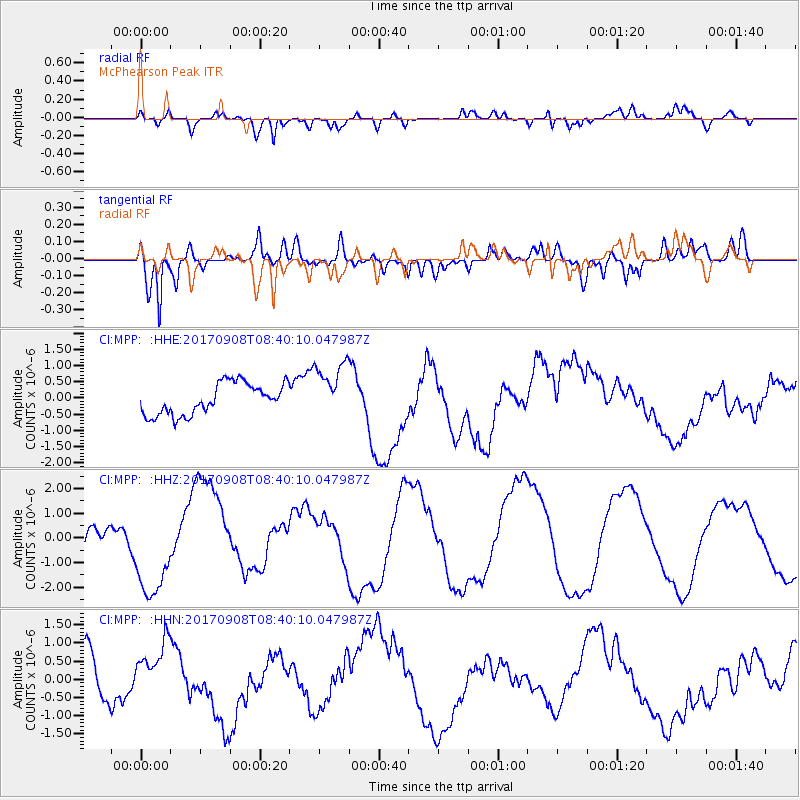
MPP McPhearson Peak - Earthquake Result Viewer
*The percent match for this event was below the threshold and hence no stack was calculated.
| Earthquake location: |
Near Coast Of Oaxaca, Mexico |
| Earthquake latitude/longitude: |
15.2/-94.2 |
| Earthquake time(UTC): |
2017/09/08 (251) 08:34:34 GMT |
| Earthquake Depth: |
51 km |
| Earthquake Magnitude: |
5.3 mb |
| Earthquake Catalog/Contributor: |
NEIC PDE/us |
|
| Network: |
CI Caltech Regional Seismic Network |
| Station: |
MPP McPhearson Peak |
| Lat/Lon: |
34.89 N/119.81 W |
| Elevation: |
1739 m |
|
| Distance: |
30.2 deg |
| Az: |
315.054 deg |
| Baz: |
123.942 deg |
| Ray Param: |
$rayparam |
*The percent match for this event was below the threshold and hence was not used in the summary stack. |
|
| Radial Match: |
66.505844 % |
| Radial Bump: |
400 |
| Transverse Match: |
62.16082 % |
| Transverse Bump: |
400 |
| SOD ConfigId: |
13570011 |
| Insert Time: |
2019-04-28 17:50:16.487 +0000 |
| GWidth: |
2.5 |
| Max Bumps: |
400 |
| Tol: |
0.001 |
|
Signal To Noise
| Channel | StoN | STA | LTA |
| CI:MPP: :HHZ:20170908T08:40:10.047987Z | 2.6975381 | 1.925993E-6 | 7.139818E-7 |
| CI:MPP: :HHN:20170908T08:40:10.047987Z | 1.3231827 | 7.635591E-7 | 5.7706245E-7 |
| CI:MPP: :HHE:20170908T08:40:10.047987Z | 1.8177619 | 8.7270973E-7 | 4.801012E-7 |
| Arrivals |
| Ps | |
| PpPs | |
| PsPs/PpSs | |


