You are here: Home > Network List > TA - USArray Transportable Network (new EarthScope stations) Stations List
> Station 122A Conniff Cattle Co., Rinco, NM, USA > Earthquake Result Viewer
122A Conniff Cattle Co., Rinco, NM, USA - Earthquake Result Viewer
| Earthquake location: |
Tonga Islands |
| Earthquake latitude/longitude: |
-21.9/-173.8 |
| Earthquake time(UTC): |
2008/10/19 (293) 05:10:33 GMT |
| Earthquake Depth: |
29 km |
| Earthquake Magnitude: |
6.8 MB, 7.0 MS, 6.9 MW, 6.9 MW |
| Earthquake Catalog/Contributor: |
WHDF/NEIC |
|
| Network: |
TA USArray Transportable Network (new EarthScope stations) |
| Station: |
122A Conniff Cattle Co., Rinco, NM, USA |
| Lat/Lon: |
32.70 N/107.00 W |
| Elevation: |
1333 m |
|
| Distance: |
83.7 deg |
| Az: |
51.238 deg |
| Baz: |
239.213 deg |
| Ray Param: |
0.04594591 |
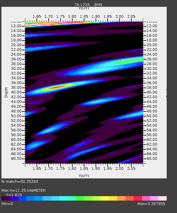
| Estimated Moho Depth: |
11.25 km |
| Estimated Crust Vp/Vs: |
1.62 |
| Assumed Crust Vp: |
6.502 km/s |
| Estimated Crust Vs: |
4.026 km/s |
| Estimated Crust Poisson's Ratio: |
0.19 |
|
| Radial Match: |
80.25284 % |
| Radial Bump: |
400 |
| Transverse Match: |
78.68264 % |
| Transverse Bump: |
400 |
| SOD ConfigId: |
2556 |
| Insert Time: |
2010-03-06 03:31:08.896 +0000 |
| GWidth: |
2.5 |
| Max Bumps: |
400 |
| Tol: |
0.001 |
|

Signal To Noise
| Channel | StoN | STA | LTA |
| TA:122A: :BHN:20081019T05:22:28.824001Z | 48.619724 | 7.303006E-6 | 1.5020665E-7 |
| TA:122A: :BHE:20081019T05:22:28.824001Z | 2.7541738 | 8.907771E-7 | 3.2342808E-7 |
| TA:122A: :BHZ:20081019T05:22:28.824001Z | 2.166528 | 1.1070957E-6 | 5.1099994E-7 |
| Arrivals |
| Ps | 1.1 SECOND |
| PpPs | 4.4 SECOND |
| PsPs/PpSs | 5.5 SECOND |


