You are here: Home > Network List > TA - USArray Transportable Network (new EarthScope stations) Stations List
> Station 122A Conniff Cattle Co., Rinco, NM, USA > Earthquake Result Viewer
122A Conniff Cattle Co., Rinco, NM, USA - Earthquake Result Viewer
| Earthquake location: |
Vanuatu Islands |
| Earthquake latitude/longitude: |
-13.5/167.0 |
| Earthquake time(UTC): |
2008/09/08 (252) 18:52:06 GMT |
| Earthquake Depth: |
110 km |
| Earthquake Magnitude: |
6.4 MB, 6.9 MW, 6.9 MW |
| Earthquake Catalog/Contributor: |
WHDF/NEIC |
|
| Network: |
TA USArray Transportable Network (new EarthScope stations) |
| Station: |
122A Conniff Cattle Co., Rinco, NM, USA |
| Lat/Lon: |
32.70 N/107.00 W |
| Elevation: |
1333 m |
|
| Distance: |
93.9 deg |
| Az: |
57.468 deg |
| Baz: |
256.566 deg |
| Ray Param: |
0.041099187 |
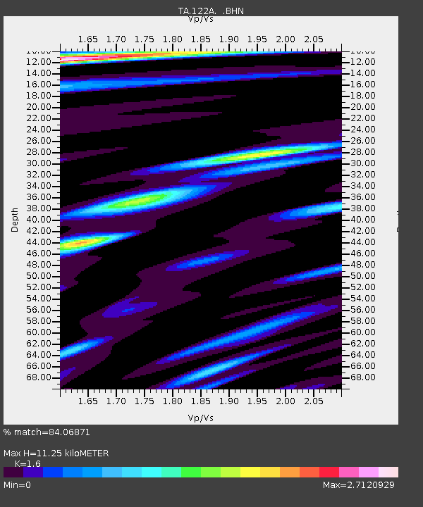
| Estimated Moho Depth: |
11.25 km |
| Estimated Crust Vp/Vs: |
1.60 |
| Assumed Crust Vp: |
6.502 km/s |
| Estimated Crust Vs: |
4.063 km/s |
| Estimated Crust Poisson's Ratio: |
0.18 |
|
| Radial Match: |
84.06871 % |
| Radial Bump: |
400 |
| Transverse Match: |
66.5701 % |
| Transverse Bump: |
400 |
| SOD ConfigId: |
2560 |
| Insert Time: |
2010-03-06 03:31:10.576 +0000 |
| GWidth: |
2.5 |
| Max Bumps: |
400 |
| Tol: |
0.001 |
|
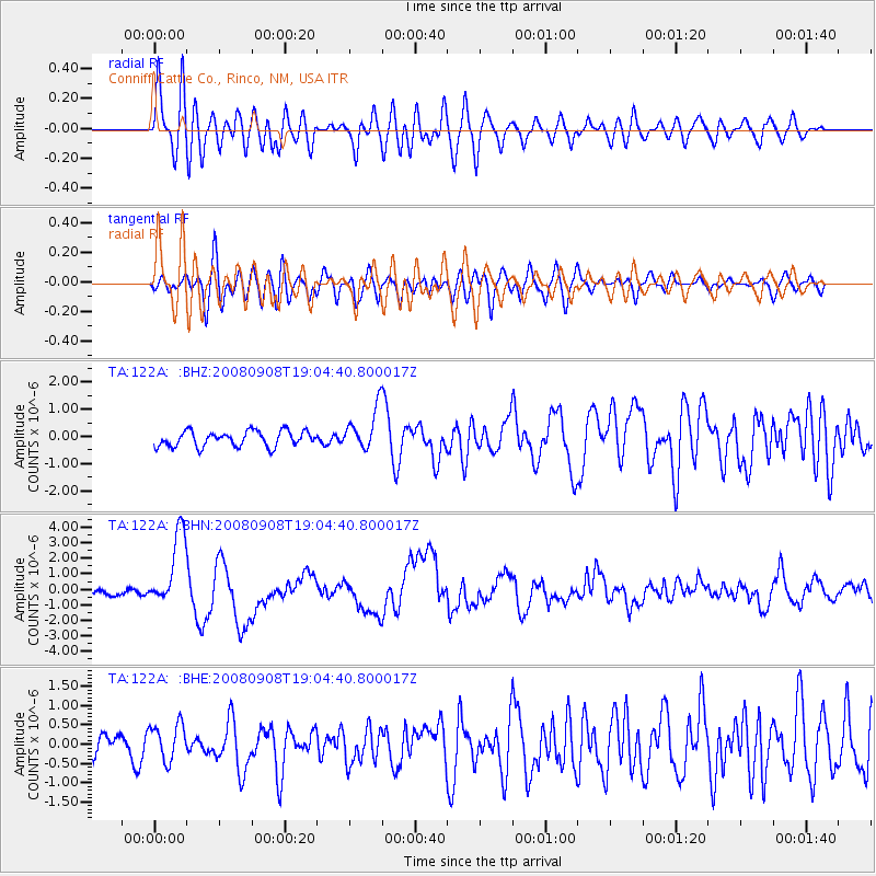
Signal To Noise
| Channel | StoN | STA | LTA |
| TA:122A: :BHN:20080908T19:04:40.800017Z | 14.637977 | 2.416358E-6 | 1.650746E-7 |
| TA:122A: :BHE:20080908T19:04:40.800017Z | 1.3879291 | 4.7324951E-7 | 3.4097528E-7 |
| TA:122A: :BHZ:20080908T19:04:40.800017Z | 2.7311068 | 7.7902456E-7 | 2.8524136E-7 |
| Arrivals |
| Ps | 1.1 SECOND |
| PpPs | 4.4 SECOND |
| PsPs/PpSs | 5.5 SECOND |


