You are here: Home > Network List > TA - USArray Transportable Network (new EarthScope stations) Stations List
> Station E29M Blow River, YT, CAN > Earthquake Result Viewer
E29M Blow River, YT, CAN - Earthquake Result Viewer
| Earthquake location: |
Near Coast Of Oaxaca, Mexico |
| Earthquake latitude/longitude: |
15.2/-94.2 |
| Earthquake time(UTC): |
2017/09/08 (251) 08:34:34 GMT |
| Earthquake Depth: |
51 km |
| Earthquake Magnitude: |
5.3 mb |
| Earthquake Catalog/Contributor: |
NEIC PDE/us |
|
| Network: |
TA USArray Transportable Network (new EarthScope stations) |
| Station: |
E29M Blow River, YT, CAN |
| Lat/Lon: |
68.39 N/137.90 W |
| Elevation: |
324 m |
|
| Distance: |
60.0 deg |
| Az: |
342.795 deg |
| Baz: |
129.569 deg |
| Ray Param: |
0.06173484 |
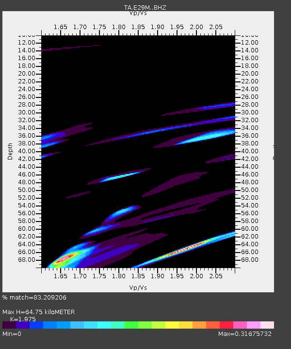
| Estimated Moho Depth: |
64.75 km |
| Estimated Crust Vp/Vs: |
1.98 |
| Assumed Crust Vp: |
5.981 km/s |
| Estimated Crust Vs: |
3.028 km/s |
| Estimated Crust Poisson's Ratio: |
0.33 |
|
| Radial Match: |
83.209206 % |
| Radial Bump: |
400 |
| Transverse Match: |
49.78701 % |
| Transverse Bump: |
149 |
| SOD ConfigId: |
13570011 |
| Insert Time: |
2019-04-28 17:52:28.079 +0000 |
| GWidth: |
2.5 |
| Max Bumps: |
400 |
| Tol: |
0.001 |
|

Signal To Noise
| Channel | StoN | STA | LTA |
| TA:E29M: :BHZ:20170908T08:44:04.699995Z | 1.3111154 | 1.5532106E-6 | 1.1846482E-6 |
| TA:E29M: :BHN:20170908T08:44:04.699995Z | 0.9108895 | 5.9746776E-7 | 6.559169E-7 |
| TA:E29M: :BHE:20170908T08:44:04.699995Z | 1.3696526 | 1.4764285E-6 | 1.0779582E-6 |
| Arrivals |
| Ps | 11 SECOND |
| PpPs | 31 SECOND |
| PsPs/PpSs | 42 SECOND |


