You are here: Home > Network List > TA - USArray Transportable Network (new EarthScope stations) Stations List
> Station 122A Conniff Cattle Co., Rinco, NM, USA > Earthquake Result Viewer
122A Conniff Cattle Co., Rinco, NM, USA - Earthquake Result Viewer
| Earthquake location: |
Near Coast Of Northern Chile |
| Earthquake latitude/longitude: |
-20.2/-70.0 |
| Earthquake time(UTC): |
2008/02/04 (035) 17:01:30 GMT |
| Earthquake Depth: |
44 km |
| Earthquake Magnitude: |
6.0 MB, 6.2 MS, 6.3 MW, 6.3 MW |
| Earthquake Catalog/Contributor: |
WHDF/NEIC |
|
| Network: |
TA USArray Transportable Network (new EarthScope stations) |
| Station: |
122A Conniff Cattle Co., Rinco, NM, USA |
| Lat/Lon: |
32.70 N/107.00 W |
| Elevation: |
1333 m |
|
| Distance: |
63.3 deg |
| Az: |
325.438 deg |
| Baz: |
140.797 deg |
| Ray Param: |
0.059552312 |
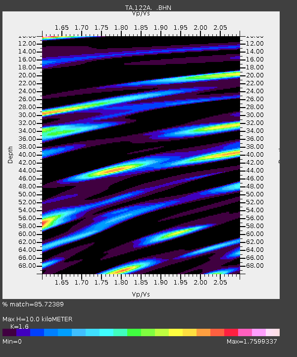
| Estimated Moho Depth: |
10.0 km |
| Estimated Crust Vp/Vs: |
1.60 |
| Assumed Crust Vp: |
6.502 km/s |
| Estimated Crust Vs: |
4.063 km/s |
| Estimated Crust Poisson's Ratio: |
0.18 |
|
| Radial Match: |
85.72389 % |
| Radial Bump: |
400 |
| Transverse Match: |
82.86008 % |
| Transverse Bump: |
400 |
| SOD ConfigId: |
2564 |
| Insert Time: |
2010-03-06 03:31:15.170 +0000 |
| GWidth: |
2.5 |
| Max Bumps: |
400 |
| Tol: |
0.001 |
|

Signal To Noise
| Channel | StoN | STA | LTA |
| TA:122A: :BHN:20080204T17:11:24.875029Z | 1.9188622 | 8.3465727E-7 | 4.3497508E-7 |
| TA:122A: :BHE:20080204T17:11:24.875029Z | 2.00529 | 1.1940521E-6 | 5.95451E-7 |
| TA:122A: :BHZ:20080204T17:11:24.875029Z | 14.5526085 | 2.6881396E-6 | 1.8471876E-7 |
| Arrivals |
| Ps | 1.0 SECOND |
| PpPs | 3.8 SECOND |
| PsPs/PpSs | 4.8 SECOND |


