You are here: Home > Network List > TA - USArray Transportable Network (new EarthScope stations) Stations List
> Station 122A Conniff Cattle Co., Rinco, NM, USA > Earthquake Result Viewer
122A Conniff Cattle Co., Rinco, NM, USA - Earthquake Result Viewer
| Earthquake location: |
East Of Kuril Islands |
| Earthquake latitude/longitude: |
46.9/155.2 |
| Earthquake time(UTC): |
2009/01/15 (015) 17:49:39 GMT |
| Earthquake Depth: |
36 km |
| Earthquake Magnitude: |
6.9 MB, 7.5 MS, 7.4 MW, 7.4 MW |
| Earthquake Catalog/Contributor: |
WHDF/NEIC |
|
| Network: |
TA USArray Transportable Network (new EarthScope stations) |
| Station: |
122A Conniff Cattle Co., Rinco, NM, USA |
| Lat/Lon: |
32.70 N/107.00 W |
| Elevation: |
1333 m |
|
| Distance: |
71.8 deg |
| Az: |
61.543 deg |
| Baz: |
314.309 deg |
| Ray Param: |
0.054019365 |
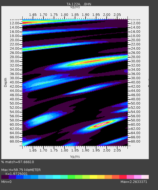
| Estimated Moho Depth: |
59.75 km |
| Estimated Crust Vp/Vs: |
1.97 |
| Assumed Crust Vp: |
6.502 km/s |
| Estimated Crust Vs: |
3.296 km/s |
| Estimated Crust Poisson's Ratio: |
0.33 |
|
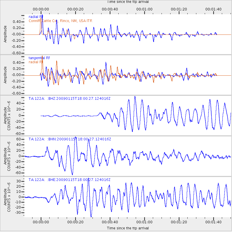
| Radial Match: |
97.66618 % |
| Radial Bump: |
400 |
| Transverse Match: |
95.83041 % |
| Transverse Bump: |
400 |
| SOD ConfigId: |
2834 |
| Insert Time: |
2010-03-06 03:31:17.004 +0000 |
| GWidth: |
2.5 |
| Max Bumps: |
400 |
| Tol: |
0.001 |
|
Signal To Noise
| Channel | StoN | STA | LTA |
| TA:122A: :BHN:20090115T18:00:27.124016Z | 19.628296 | 1.3930335E-5 | 7.097068E-7 |
| TA:122A: :BHE:20090115T18:00:27.124016Z | 4.417027 | 4.0100995E-6 | 9.07873E-7 |
| TA:122A: :BHZ:20090115T18:00:27.124016Z | 3.6788278 | 4.4330945E-6 | 1.2050291E-6 |
| Arrivals |
| Ps | 9.2 SECOND |
| PpPs | 26 SECOND |
| PsPs/PpSs | 36 SECOND |


