You are here: Home > Network List > TA - USArray Transportable Network (new EarthScope stations) Stations List
> Station 122A Conniff Cattle Co., Rinco, NM, USA > Earthquake Result Viewer
122A Conniff Cattle Co., Rinco, NM, USA - Earthquake Result Viewer
| Earthquake location: |
Kuril Islands |
| Earthquake latitude/longitude: |
50.8/155.0 |
| Earthquake time(UTC): |
2009/04/21 (111) 05:26:11 GMT |
| Earthquake Depth: |
152 km |
| Earthquake Magnitude: |
6.0 MB, 6.2 MW, 6.2 MW |
| Earthquake Catalog/Contributor: |
WHDF/NEIC |
|
| Network: |
TA USArray Transportable Network (new EarthScope stations) |
| Station: |
122A Conniff Cattle Co., Rinco, NM, USA |
| Lat/Lon: |
32.70 N/107.00 W |
| Elevation: |
1333 m |
|
| Distance: |
70.0 deg |
| Az: |
62.667 deg |
| Baz: |
318.078 deg |
| Ray Param: |
0.05483888 |
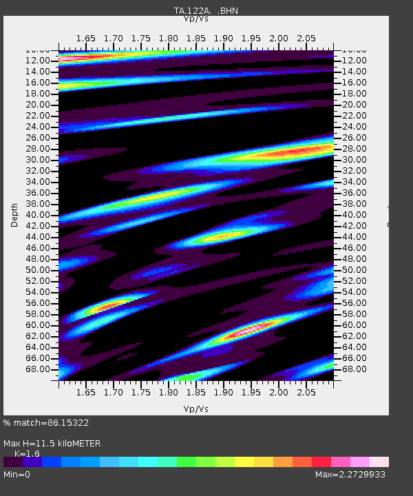
| Estimated Moho Depth: |
11.5 km |
| Estimated Crust Vp/Vs: |
1.60 |
| Assumed Crust Vp: |
6.502 km/s |
| Estimated Crust Vs: |
4.063 km/s |
| Estimated Crust Poisson's Ratio: |
0.18 |
|
| Radial Match: |
86.15322 % |
| Radial Bump: |
400 |
| Transverse Match: |
80.10889 % |
| Transverse Bump: |
400 |
| SOD ConfigId: |
2658 |
| Insert Time: |
2010-03-06 03:31:37.616 +0000 |
| GWidth: |
2.5 |
| Max Bumps: |
400 |
| Tol: |
0.001 |
|

Signal To Noise
| Channel | StoN | STA | LTA |
| TA:122A: :BHN:20090421T05:36:35.949016Z | 13.620605 | 2.5464876E-6 | 1.8695847E-7 |
| TA:122A: :BHE:20090421T05:36:35.949016Z | 1.8140132 | 5.787401E-7 | 3.1903852E-7 |
| TA:122A: :BHZ:20090421T05:36:35.949016Z | 2.5041635 | 7.104342E-7 | 2.837012E-7 |
| Arrivals |
| Ps | 1.1 SECOND |
| PpPs | 4.4 SECOND |
| PsPs/PpSs | 5.5 SECOND |


