You are here: Home > Network List > US - United States National Seismic Network Stations List
> Station EGMT Eagleton, Montana, USA > Earthquake Result Viewer
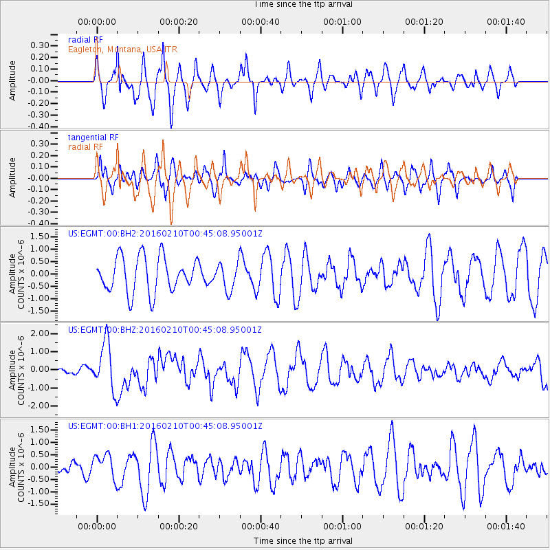
EGMT Eagleton, Montana, USA - Earthquake Result Viewer
*The percent match for this event was below the threshold and hence no stack was calculated.
| Earthquake location: |
Near Coast Of Central Chile |
| Earthquake latitude/longitude: |
-30.6/-71.6 |
| Earthquake time(UTC): |
2016/02/10 (041) 00:33:05 GMT |
| Earthquake Depth: |
32 km |
| Earthquake Magnitude: |
6.3 MWB |
| Earthquake Catalog/Contributor: |
NEIC PDE/NEIC COMCAT |
|
| Network: |
US United States National Seismic Network |
| Station: |
EGMT Eagleton, Montana, USA |
| Lat/Lon: |
48.02 N/109.75 W |
| Elevation: |
1055 m |
|
| Distance: |
85.5 deg |
| Az: |
335.427 deg |
| Baz: |
147.728 deg |
| Ray Param: |
$rayparam |
*The percent match for this event was below the threshold and hence was not used in the summary stack. |
|
| Radial Match: |
67.71238 % |
| Radial Bump: |
400 |
| Transverse Match: |
61.59157 % |
| Transverse Bump: |
400 |
| SOD ConfigId: |
1427151 |
| Insert Time: |
2016-02-24 01:00:05.183 +0000 |
| GWidth: |
2.5 |
| Max Bumps: |
400 |
| Tol: |
0.001 |
|
Signal To Noise
| Channel | StoN | STA | LTA |
| US:EGMT:00:BHZ:20160210T00:45:08.95001Z | 4.946974 | 1.3524947E-6 | 2.733984E-7 |
| US:EGMT:00:BH1:20160210T00:45:08.95001Z | 1.89204 | 5.010765E-7 | 2.64834E-7 |
| US:EGMT:00:BH2:20160210T00:45:08.95001Z | 0.7927965 | 5.745343E-7 | 7.246932E-7 |
| Arrivals |
| Ps | |
| PpPs | |
| PsPs/PpSs | |


