You are here: Home > Network List > TA - USArray Transportable Network (new EarthScope stations) Stations List
> Station D25K Kavik River, AK, USA > Earthquake Result Viewer
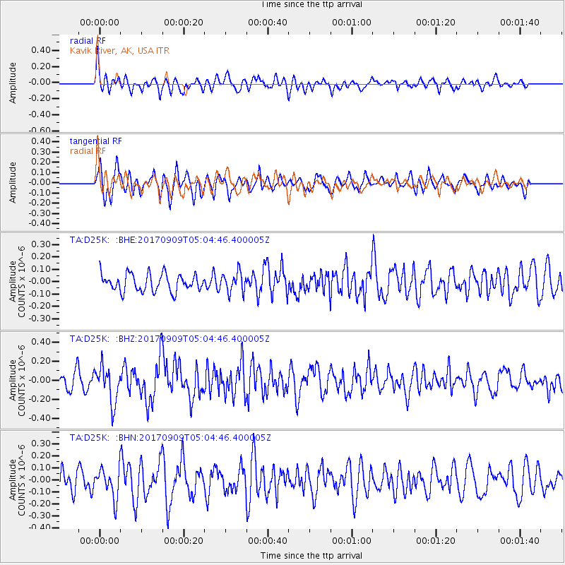
D25K Kavik River, AK, USA - Earthquake Result Viewer
*The percent match for this event was below the threshold and hence no stack was calculated.
| Earthquake location: |
Near Coast Of Chiapas, Mexico |
| Earthquake latitude/longitude: |
15.1/-93.9 |
| Earthquake time(UTC): |
2017/09/09 (252) 04:54:52 GMT |
| Earthquake Depth: |
29 km |
| Earthquake Magnitude: |
5.5 Mww |
| Earthquake Catalog/Contributor: |
NEIC PDE/us |
|
| Network: |
TA USArray Transportable Network (new EarthScope stations) |
| Station: |
D25K Kavik River, AK, USA |
| Lat/Lon: |
69.32 N/146.38 W |
| Elevation: |
770 m |
|
| Distance: |
63.2 deg |
| Az: |
341.611 deg |
| Baz: |
120.919 deg |
| Ray Param: |
$rayparam |
*The percent match for this event was below the threshold and hence was not used in the summary stack. |
|
| Radial Match: |
56.50783 % |
| Radial Bump: |
400 |
| Transverse Match: |
64.182365 % |
| Transverse Bump: |
400 |
| SOD ConfigId: |
13570011 |
| Insert Time: |
2019-04-28 18:02:15.739 +0000 |
| GWidth: |
2.5 |
| Max Bumps: |
400 |
| Tol: |
0.001 |
|
Signal To Noise
| Channel | StoN | STA | LTA |
| TA:D25K: :BHZ:20170909T05:04:46.400005Z | 1.849924 | 1.9448711E-7 | 1.05132486E-7 |
| TA:D25K: :BHN:20170909T05:04:46.400005Z | 1.5317252 | 1.2748252E-7 | 8.3228066E-8 |
| TA:D25K: :BHE:20170909T05:04:46.400005Z | 1.2014744 | 8.113237E-8 | 6.752734E-8 |
| Arrivals |
| Ps | |
| PpPs | |
| PsPs/PpSs | |


