You are here: Home > Network List > TA - USArray Transportable Network (new EarthScope stations) Stations List
> Station I23K Minto, Yukon-Koyukuk, AK, USA > Earthquake Result Viewer
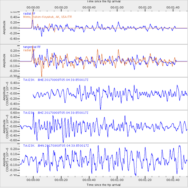
I23K Minto, Yukon-Koyukuk, AK, USA - Earthquake Result Viewer
*The percent match for this event was below the threshold and hence no stack was calculated.
| Earthquake location: |
Near Coast Of Chiapas, Mexico |
| Earthquake latitude/longitude: |
15.1/-93.9 |
| Earthquake time(UTC): |
2017/09/09 (252) 04:54:52 GMT |
| Earthquake Depth: |
29 km |
| Earthquake Magnitude: |
5.5 Mww |
| Earthquake Catalog/Contributor: |
NEIC PDE/us |
|
| Network: |
TA USArray Transportable Network (new EarthScope stations) |
| Station: |
I23K Minto, Yukon-Koyukuk, AK, USA |
| Lat/Lon: |
65.15 N/149.36 W |
| Elevation: |
149 m |
|
| Distance: |
62.2 deg |
| Az: |
336.84 deg |
| Baz: |
115.978 deg |
| Ray Param: |
$rayparam |
*The percent match for this event was below the threshold and hence was not used in the summary stack. |
|
| Radial Match: |
65.5397 % |
| Radial Bump: |
400 |
| Transverse Match: |
60.377113 % |
| Transverse Bump: |
398 |
| SOD ConfigId: |
13570011 |
| Insert Time: |
2019-04-28 18:02:48.057 +0000 |
| GWidth: |
2.5 |
| Max Bumps: |
400 |
| Tol: |
0.001 |
|
Signal To Noise
| Channel | StoN | STA | LTA |
| TA:I23K: :BHZ:20170909T05:04:39.850017Z | 2.6377285 | 2.866929E-7 | 1.0868931E-7 |
| TA:I23K: :BHN:20170909T05:04:39.850017Z | 0.82411075 | 1.0550019E-7 | 1.28017E-7 |
| TA:I23K: :BHE:20170909T05:04:39.850017Z | 1.5146403 | 1.7202929E-7 | 1.13577656E-7 |
| Arrivals |
| Ps | |
| PpPs | |
| PsPs/PpSs | |


