You are here: Home > Network List > TA - USArray Transportable Network (new EarthScope stations) Stations List
> Station R31K City Hall, Gustavus, AK, USA > Earthquake Result Viewer
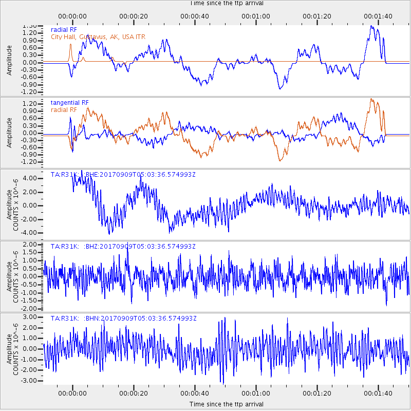
R31K City Hall, Gustavus, AK, USA - Earthquake Result Viewer
*The percent match for this event was below the threshold and hence no stack was calculated.
| Earthquake location: |
Near Coast Of Chiapas, Mexico |
| Earthquake latitude/longitude: |
15.1/-93.9 |
| Earthquake time(UTC): |
2017/09/09 (252) 04:54:52 GMT |
| Earthquake Depth: |
29 km |
| Earthquake Magnitude: |
5.5 Mww |
| Earthquake Catalog/Contributor: |
NEIC PDE/us |
|
| Network: |
TA USArray Transportable Network (new EarthScope stations) |
| Station: |
R31K City Hall, Gustavus, AK, USA |
| Lat/Lon: |
58.41 N/135.74 W |
| Elevation: |
15 m |
|
| Distance: |
53.2 deg |
| Az: |
334.016 deg |
| Baz: |
126.482 deg |
| Ray Param: |
$rayparam |
*The percent match for this event was below the threshold and hence was not used in the summary stack. |
|
| Radial Match: |
21.443956 % |
| Radial Bump: |
400 |
| Transverse Match: |
38.94393 % |
| Transverse Bump: |
400 |
| SOD ConfigId: |
13570011 |
| Insert Time: |
2019-04-28 18:03:09.923 +0000 |
| GWidth: |
2.5 |
| Max Bumps: |
400 |
| Tol: |
0.001 |
|
Signal To Noise
| Channel | StoN | STA | LTA |
| TA:R31K: :BHZ:20170909T05:03:36.574993Z | 1.0399554 | 5.782225E-7 | 5.560071E-7 |
| TA:R31K: :BHN:20170909T05:03:36.574993Z | 0.9695398 | 1.2207761E-6 | 1.2591294E-6 |
| TA:R31K: :BHE:20170909T05:03:36.574993Z | 1.2879255 | 3.0622916E-6 | 2.3776931E-6 |
| Arrivals |
| Ps | |
| PpPs | |
| PsPs/PpSs | |


