You are here: Home > Network List > US - United States National Seismic Network Stations List
> Station MSO Missoula, Montana, USA > Earthquake Result Viewer
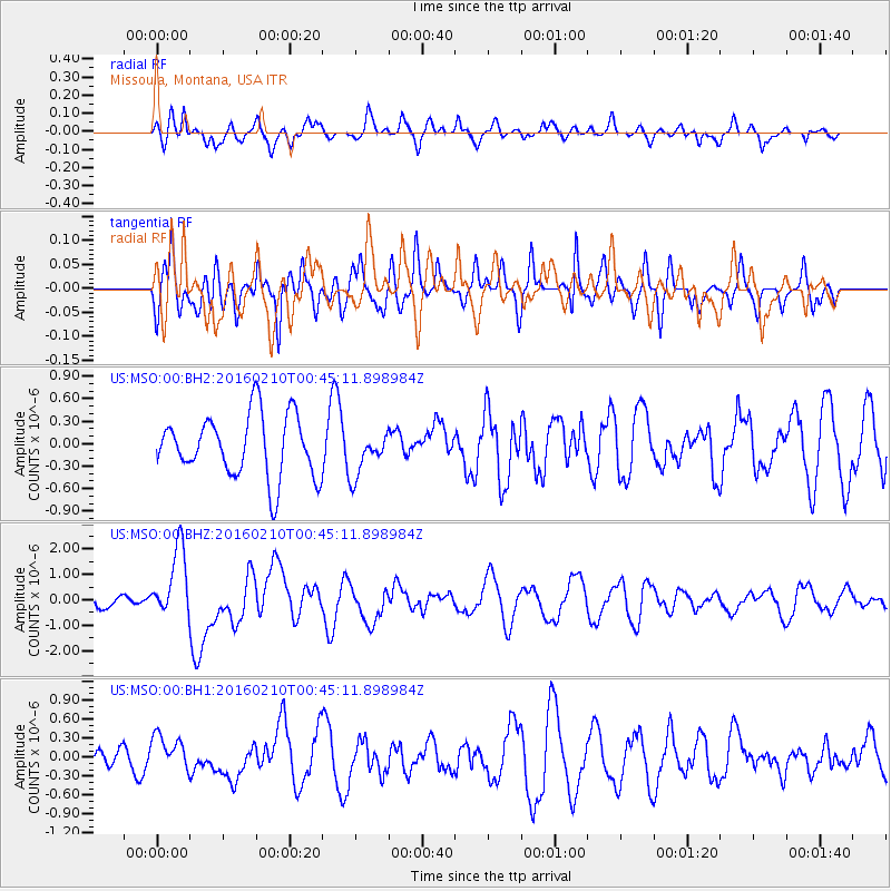
MSO Missoula, Montana, USA - Earthquake Result Viewer
*The percent match for this event was below the threshold and hence no stack was calculated.
| Earthquake location: |
Near Coast Of Central Chile |
| Earthquake latitude/longitude: |
-30.6/-71.6 |
| Earthquake time(UTC): |
2016/02/10 (041) 00:33:05 GMT |
| Earthquake Depth: |
32 km |
| Earthquake Magnitude: |
6.3 MWB |
| Earthquake Catalog/Contributor: |
NEIC PDE/NEIC COMCAT |
|
| Network: |
US United States National Seismic Network |
| Station: |
MSO Missoula, Montana, USA |
| Lat/Lon: |
46.83 N/113.94 W |
| Elevation: |
1264 m |
|
| Distance: |
86.0 deg |
| Az: |
332.394 deg |
| Baz: |
144.429 deg |
| Ray Param: |
$rayparam |
*The percent match for this event was below the threshold and hence was not used in the summary stack. |
|
| Radial Match: |
42.954113 % |
| Radial Bump: |
400 |
| Transverse Match: |
60.289616 % |
| Transverse Bump: |
400 |
| SOD ConfigId: |
1427151 |
| Insert Time: |
2016-02-24 01:01:37.513 +0000 |
| GWidth: |
2.5 |
| Max Bumps: |
400 |
| Tol: |
0.001 |
|
Signal To Noise
| Channel | StoN | STA | LTA |
| US:MSO:00:BHZ:20160210T00:45:11.898984Z | 6.034264 | 1.3740248E-6 | 2.2770381E-7 |
| US:MSO:00:BH1:20160210T00:45:11.898984Z | 1.2725935 | 2.7473456E-7 | 2.1588556E-7 |
| US:MSO:00:BH2:20160210T00:45:11.898984Z | 0.6995444 | 2.8800176E-7 | 4.1169903E-7 |
| Arrivals |
| Ps | |
| PpPs | |
| PsPs/PpSs | |


