You are here: Home > Network List > TA - USArray Transportable Network (new EarthScope stations) Stations List
> Station G22K Bettles, AK, USA > Earthquake Result Viewer
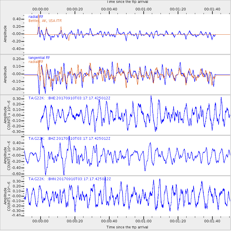
G22K Bettles, AK, USA - Earthquake Result Viewer
*The percent match for this event was below the threshold and hence no stack was calculated.
| Earthquake location: |
Near Coast Of Oaxaca, Mexico |
| Earthquake latitude/longitude: |
15.5/-94.3 |
| Earthquake time(UTC): |
2017/09/10 (253) 03:07:26 GMT |
| Earthquake Depth: |
53 km |
| Earthquake Magnitude: |
5.7 Mww |
| Earthquake Catalog/Contributor: |
NEIC PDE/us |
|
| Network: |
TA USArray Transportable Network (new EarthScope stations) |
| Station: |
G22K Bettles, AK, USA |
| Lat/Lon: |
66.92 N/151.51 W |
| Elevation: |
205 m |
|
| Distance: |
63.3 deg |
| Az: |
338.232 deg |
| Baz: |
114.9 deg |
| Ray Param: |
$rayparam |
*The percent match for this event was below the threshold and hence was not used in the summary stack. |
|
| Radial Match: |
60.62405 % |
| Radial Bump: |
400 |
| Transverse Match: |
59.13858 % |
| Transverse Bump: |
400 |
| SOD ConfigId: |
13570011 |
| Insert Time: |
2019-04-28 18:08:22.141 +0000 |
| GWidth: |
2.5 |
| Max Bumps: |
400 |
| Tol: |
0.001 |
|
Signal To Noise
| Channel | StoN | STA | LTA |
| TA:G22K: :BHZ:20170910T03:17:17.425012Z | 3.477236 | 3.4366244E-7 | 9.8832075E-8 |
| TA:G22K: :BHN:20170910T03:17:17.425012Z | 1.013125 | 1.1046542E-7 | 1.0903435E-7 |
| TA:G22K: :BHE:20170910T03:17:17.425012Z | 1.7360076 | 1.6333266E-7 | 9.408522E-8 |
| Arrivals |
| Ps | |
| PpPs | |
| PsPs/PpSs | |


