You are here: Home > Network List > TA - USArray Transportable Network (new EarthScope stations) Stations List
> Station G21K Allakaket, AK, USA > Earthquake Result Viewer
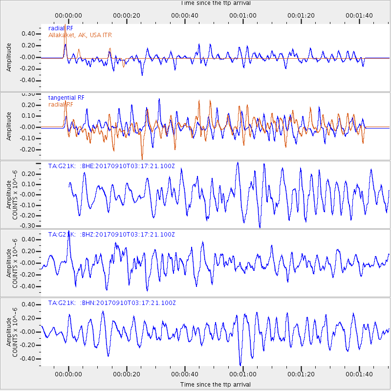
G21K Allakaket, AK, USA - Earthquake Result Viewer
*The percent match for this event was below the threshold and hence no stack was calculated.
| Earthquake location: |
Near Coast Of Oaxaca, Mexico |
| Earthquake latitude/longitude: |
15.5/-94.3 |
| Earthquake time(UTC): |
2017/09/10 (253) 03:07:26 GMT |
| Earthquake Depth: |
53 km |
| Earthquake Magnitude: |
5.7 Mww |
| Earthquake Catalog/Contributor: |
NEIC PDE/us |
|
| Network: |
TA USArray Transportable Network (new EarthScope stations) |
| Station: |
G21K Allakaket, AK, USA |
| Lat/Lon: |
66.52 N/153.51 W |
| Elevation: |
446 m |
|
| Distance: |
63.8 deg |
| Az: |
337.457 deg |
| Baz: |
112.721 deg |
| Ray Param: |
$rayparam |
*The percent match for this event was below the threshold and hence was not used in the summary stack. |
|
| Radial Match: |
59.78031 % |
| Radial Bump: |
400 |
| Transverse Match: |
41.58125 % |
| Transverse Bump: |
367 |
| SOD ConfigId: |
13570011 |
| Insert Time: |
2019-04-28 18:08:22.307 +0000 |
| GWidth: |
2.5 |
| Max Bumps: |
400 |
| Tol: |
0.001 |
|
Signal To Noise
| Channel | StoN | STA | LTA |
| TA:G21K: :BHZ:20170910T03:17:21.100Z | 3.0023665 | 2.3395593E-7 | 7.792384E-8 |
| TA:G21K: :BHN:20170910T03:17:21.100Z | 2.4106896 | 1.17198134E-7 | 4.861602E-8 |
| TA:G21K: :BHE:20170910T03:17:21.100Z | 0.92888427 | 7.5198614E-8 | 8.095584E-8 |
| Arrivals |
| Ps | |
| PpPs | |
| PsPs/PpSs | |


