You are here: Home > Network List > TA - USArray Transportable Network (new EarthScope stations) Stations List
> Station G23K Bananza Creek, AK, USA > Earthquake Result Viewer
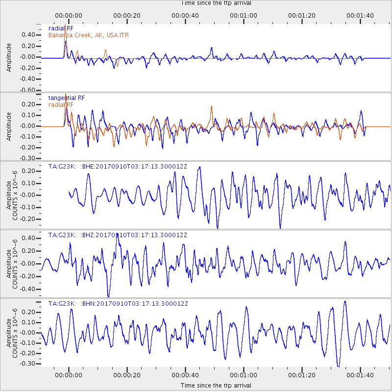
G23K Bananza Creek, AK, USA - Earthquake Result Viewer
*The percent match for this event was below the threshold and hence no stack was calculated.
| Earthquake location: |
Near Coast Of Oaxaca, Mexico |
| Earthquake latitude/longitude: |
15.5/-94.3 |
| Earthquake time(UTC): |
2017/09/10 (253) 03:07:26 GMT |
| Earthquake Depth: |
53 km |
| Earthquake Magnitude: |
5.7 Mww |
| Earthquake Catalog/Contributor: |
NEIC PDE/us |
|
| Network: |
TA USArray Transportable Network (new EarthScope stations) |
| Station: |
G23K Bananza Creek, AK, USA |
| Lat/Lon: |
66.71 N/150.02 W |
| Elevation: |
746 m |
|
| Distance: |
62.6 deg |
| Az: |
338.302 deg |
| Baz: |
116.294 deg |
| Ray Param: |
$rayparam |
*The percent match for this event was below the threshold and hence was not used in the summary stack. |
|
| Radial Match: |
51.654137 % |
| Radial Bump: |
358 |
| Transverse Match: |
56.698345 % |
| Transverse Bump: |
369 |
| SOD ConfigId: |
13570011 |
| Insert Time: |
2019-04-28 18:08:22.551 +0000 |
| GWidth: |
2.5 |
| Max Bumps: |
400 |
| Tol: |
0.001 |
|
Signal To Noise
| Channel | StoN | STA | LTA |
| TA:G23K: :BHZ:20170910T03:17:13.300012Z | 2.5088637 | 1.5950968E-7 | 6.3578455E-8 |
| TA:G23K: :BHN:20170910T03:17:13.300012Z | 1.7111708 | 1.2220272E-7 | 7.141468E-8 |
| TA:G23K: :BHE:20170910T03:17:13.300012Z | 1.4803894 | 9.408775E-8 | 6.355609E-8 |
| Arrivals |
| Ps | |
| PpPs | |
| PsPs/PpSs | |


