You are here: Home > Network List > TA - USArray Transportable Network (new EarthScope stations) Stations List
> Station P17K Kvichak River, AK, USA > Earthquake Result Viewer
P17K Kvichak River, AK, USA - Earthquake Result Viewer
*The percent match for this event was below the threshold and hence no stack was calculated.
| Earthquake location: |
Near Coast Of Oaxaca, Mexico |
| Earthquake latitude/longitude: |
15.5/-94.3 |
| Earthquake time(UTC): |
2017/09/10 (253) 03:07:26 GMT |
| Earthquake Depth: |
53 km |
| Earthquake Magnitude: |
5.7 Mww |
| Earthquake Catalog/Contributor: |
NEIC PDE/us |
|
| Network: |
TA USArray Transportable Network (new EarthScope stations) |
| Station: |
P17K Kvichak River, AK, USA |
| Lat/Lon: |
59.20 N/156.44 W |
| Elevation: |
91 m |
|
| Distance: |
62.6 deg |
| Az: |
329.197 deg |
| Baz: |
106.383 deg |
| Ray Param: |
$rayparam |
*The percent match for this event was below the threshold and hence was not used in the summary stack. |
|
| Radial Match: |
71.671455 % |
| Radial Bump: |
400 |
| Transverse Match: |
56.265133 % |
| Transverse Bump: |
400 |
| SOD ConfigId: |
13570011 |
| Insert Time: |
2019-04-28 18:08:50.310 +0000 |
| GWidth: |
2.5 |
| Max Bumps: |
400 |
| Tol: |
0.001 |
|
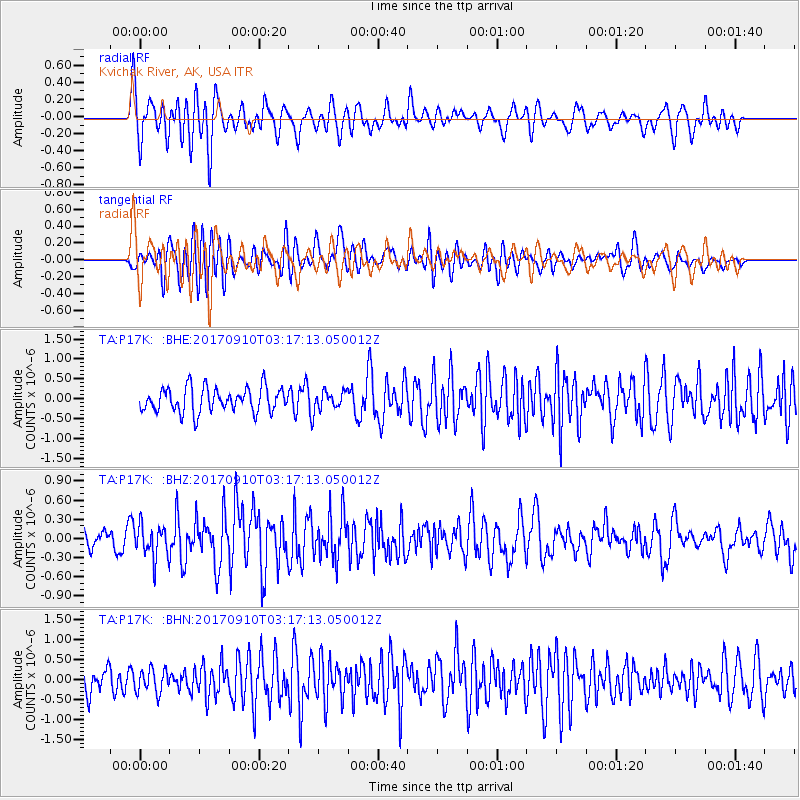
Signal To Noise
| Channel | StoN | STA | LTA |
| TA:P17K: :BHZ:20170910T03:17:13.050012Z | 2.3079987 | 2.659466E-7 | 1.15228225E-7 |
| TA:P17K: :BHN:20170910T03:17:13.050012Z | 0.90911716 | 2.9159168E-7 | 3.2074158E-7 |
| TA:P17K: :BHE:20170910T03:17:13.050012Z | 0.6983359 | 2.174005E-7 | 3.1131225E-7 |
| Arrivals |
| Ps | |
| PpPs | |
| PsPs/PpSs | |


